
Welcome to the first edition of The Strategic Week for 2016 – and apologies for the delay in this edition which was meant to appear last week. This edition also covers the period since the appearance of TSW 3 on 18 December and as with that edition there is extended coverage of the NSW Local Government reform process.
Governance
Federal Minister for Cities resigns after only three months
The Federal Minister for Cities and the Built Environment Jamie Briggs resigned on 29 December following a late-night incident during an official overseas visit in November involving a female public servant in a Hong Kong bar. Mr Briggs, who was appointed to the new portfolio only at the end of September, will be replaced by the Minister for the Environment Greg Hunt.
NSW council merger proposals delegated amid divided responses to reforms
A group of delegates has been appointed to examine and report on the NSW Government’s recently-announced council merger proposals. The Minister for Local Government referred the merger proposals to the CEO of the Office of Local Government for “examination and report under the Local Government Act”. The CEO in turn has passed these activities on to the 18 appointed delegates who will conduct inquiries, receive submissions and prepare reports on the proposals based on the factors outlined in the Act, with submissions being received until 28 February 2016. The reports will be considered by both the Minister and the NSW Local Government Boundaries Commission.
The process is described on the NSW Council Boundary Review website which also lists the names of the delegates and describes the council merger proposals they will each be assessing. While there is a strong record of experience in senior management positions in local and state government in the delegates’ CVs, only three women have been appointed.

Criticism of the proposals has continued to intensify despite the summer holiday break, with opposition coming not just from the affected councils. According to an ABC news report 500 Kiama residents attended a recent meeting to protest against the proposed merger of their council with Shoalhaven council, calling on the local state member to introduce a private members bill to exempt Kiama from his own government’s policy.
Professor Graham Sansom who chaired the Independent Local Government Review Panel which initiated the reform process has also been highly critical, claiming that the government’s announcement “fails the test of carefully structured strategic reform”, according to media reports.
“It looks like a bit of a grab bag of some changes that are close to what we suggested and make a lot of sense and other changes which I find extremely hard to understand what on earth they are meant to achieve other than presumably some political objective,” Prof. Sansom said. “The reforms are part of a pattern which tells me that local government in NSW is seen as less and less relevant on the big picture issues …They are a crab-like step sideways, they are not a step forward.”
Opposition Leader Luke Foley quoted Prof. Sansom in an opinion piece which also strongly attacked the proposals. Mr Foley was particularly critical of the proposals to split Warringah Council to merge it with Manly and Pittwater Councils and to also split off sections of Parramatta to form a new council to the south.
“Instead of outcomes underpinned by expert analysis, advice and research, what we have is the greatest act of boundary rigging in Australian politics since Joh Bjelke-Petersen’s Queensland gerrymander in the 1970s,” Mr Foley concluded.
The proposals have however received support in some quarters, although with some qualifications. The Urban Taskforce stated that “Reducing Sydney’s 43 councils to 25 will drive reform that will improve performance while still keeping a local identity for councils”, though it expressed concerns that the proposed mergers “do not align with some of the Planning District boundaries as defined in the Metropolitan Strategy”, citing the proposed The Hills and Hawkesbury Councils merger as an example that would result in a cross-boundary council.
While criticising aspects of the proposals including the timing of the announcement just before Christmas, a Sydney Morning Herald editorial also expressed support. “It is not the sort of festive gift many communities will welcome, but they should, because in the long run, they and the state will benefit,”, the paper noted.
It described the government’s record in selling the reforms as “patchy”, noting that its public commitment has “ebbed and flowed” and that changing the IPART criteria for describing what made councils fit for the future had “eroded confidence”. The SMH however praised the decision to use a reconstituted Boundaries Commission process rather than the option of “doing deals with the Upper House crossbenchers to enforce mergers”.
The Herald concludes that while Mr Baird still has “significant political capital on which to draw” though if he gets the final decisions “wrong”, the “backlash will be fierce”. The paper states however that if in the end the merger proposals succeed, “that will be a victory for efficiency and effective government”.
NSW local government reform – the long view
A useful perspective on the long history of local government reform proposals in NSW is provided by Bligh Grant in the Australian Centre of Excellence for Local Government* (ACELG) blog, The Town Crier. Grant notes that reform proposals are “nothing new” and date back to at least 1898, with five attempts between then and 1948. This follows an earlier article by Grant describing the current processes. In the second article Grant notes that “all of these processes represent two fundamental trajectories for reform, namely proposed amalgamation – particularly for Sydney metropolitan councils – and the move toward metropolitan-wide governance”. He concludes:
“… it is not merely the twin policy goals – amalgamation and metro-wide governance – that are immediately similar in the ‘eternal return’ of Sydney’s metropolitan reform. On the contrary: It is the sites of conflict over both these issues – the seeking of advice from specialist commissions (in 1913 a Royal Commission; in 2012-13 the ILGRP, for example); and in particular the power-plays between the two houses of the NSW Parliament, through which we are reminded of the relationships between local governments and the Legislature, that are strikingly similar.”
* The author of The Strategic Week is an ACELG Associate.
Greater Sydney Commission Chair gets a seat – or two – at infrastructure table
Both the Chair of the Greater Sydney Commission (GSC), Ms Lucy Turnbull, and its CEO Sarah Hill will attend key meetings of the powerful infrastructure committee of NSW cabinet when it discusses issues related to Sydney. As a media report notes, the addition of the GSC Chair and CEO to the committee “shows just how influential the commission will be in shaping of the city’s future”.
Planning
Noise issue dominates Western Sydney airport debate as consultation period closes
The 60-day community consultation period for the draft Western Sydney Airport Plan and draft Environmental Impact Statement closed on 18 December 2015. According to the Deputy Prime Minister and Minister for Infrastructure and regional Development Warren Truss over 4,500 submissions were received and nearly 1,500 people attended 16 public information sessions.
The Minister’s media release seemed to suggest that construction of the airport was a fait accompli, stating that while the government would “take the community’s feedback on board” as it finalised the EIS and was “committed to continuing to consult with the community as this transformational project develops, with the first flights set to land around 2025”.
The main issue of concern regarding the proposed airport continues to be aircraft noise. One media report claimed that a federal government proposal for stricter noise controls near Sydney’s second airport could “expose it to a wave of compensation claims”. The noise exclusion zone would increase from 50 to 400 square kilometres and would include growth areas and established suburbs.
The Mayor of Blacktown, Stephen Bali who has been campaigning for compensation for residents in the flight path said the document “completely demolishes Truss’ argument that noise will be a non-issue”. In another report Urban Taskforce CEO Chris Johnson CEO claimed “at least 10,000 proposed new homes could be stopped if the new standard is adopted.”
Record NSW building numbers claimed but trending downwards
NSW Planning Minister Rob Stokes has announced that there were nearly 66,500 housing approvals in the year to November 2015, the highest result on record. NSW also had the highest annual growth in approvals of all mainland states. The Minister also announced that a record $34 billion worth of construction was approved in the 2014/15 financial year. This represented over 90,000 approvals, a seven per cent increase on the previous year’s figures of 84,000 approvals worth $29 billion.
A closer analysis of the figures reveals a mixed picture, however. The November Australian Bureau of Statistics (ABS) release of building approvals information indicates that the trend estimate for total dwellings approved in NSW fell by 2.8% and has fallen for the past five months. The estimate for the number of approvals of private dwelling houses decreased by 0.5% and has also fallen for the past five months. The Sydney Morning Herald claimed that the overall figures also revealed that 75% “more people are building on their blocks of land, as subdivisions or granny flats, than five years ago”.
Land values increase, especially in Western Sydney
Figures released by NSW Valuer General Simon Gilkes indicate NSW land values totalled over $1.34 trillion in 2014/15, a 19.6% increase on last year’s $1.12 trillion total. “Land values in Sydney’s West underwent a boom in the last financial year far exceeding the rest of the greater metropolitan area”, Mr Gilkes said, with the local government areas of Parramatta, Blacktown and Holroyd recording the strongest growth.
Blacktown topped the state, with 47% growth in the value of residential land, followed by Holroyd (38%) and Parramatta (35.9%). Two other Western Sydney council areas, Fairfield and Auburn, were also in the top nine LGAs with growth over 30%.
Auckland Mayor identifies cities as the “first responders” to climate change
In an opinion piece for the New Zealand Herald Auckland Mayor Len Brown has indicated his determination to tackle the challenge of climate change “head on”.
“Cities will be the first responders because they know what is at stake. City action could make up a third of the shortfall between the Paris Agreement’s ambitions and current country commitments – that’s 3.7 gigatons of urban greenhouse gas emissions by 2030,” Mr Brown said.
Along with its recently-announced membership of the C40 Cities Climate Change Group Mr Brown identified Auckland’s consolidated governance as a factor in this process.
“As a united Auckland, we have an unprecedented opportunity to respond rapidly and strategically to affect the kinds of changes needed to ensure this city’s future” he said.
Mr Brown also noted that the council has set a target of reducing greenhouse gas emissions by 40% by 2040 (relative to 1990 levels) and that $20 billion will be invested over 10 years to create a modern, efficient and sustainable multi-modal public transport system which was already attracting growth in patronage of around 10% annually.
“As part of the C40 network, we can engage with cities facing similar challenges, enhancing Auckland’s ability to benefit from their expertise, tools and programmes,” Mr Brown concluded.
Infrastructure
Federal Opposition seeks probe into infrastructure spending – and criticises transport projects “propaganda”
The federal opposition has written to the Australian National Office of Audit requesting a review of “the Turnbull Government’s entire infrastructure program amid a 20 per cent decline in infrastructure investment and the collapse of two of its major road projects,” according to a media release from the Shadow Minister for Infrastructure and Transport, Citues and Tourism Anthony Albanese.
The media release also accused Infrastructure Minister Warren Truss of wanting to “raid his own infrastructure budget for $18 million which he plans to squander on advertisements about his own performance”
The Shadow Minister also claims that public infrastructure investment “plunged 20%” between the September quarter of 2013 and the June quarter of 2015 and that two projects, Melbourne’s East-West Link and the Perth Freight Link have “collapsed” while the budget for Sydney’s Westconnex toll road “has blown out from $10 billion to $16.8 billion”.
“The government has cut funding for public transport projects and re-allocated it to new toll road projects which it did not subject to cost-benefit analysis to determine whether they represented value for money,” Mr Albanese said.
Transport: Sydney Metro
Metro tunnelling completed ahead of time
The tunnelling for Sydney’s Metro Northwest has been completed with the last of the four tunnelling machines breaking through to connect with the future Cherrybrook station.
The NSW Premier Mike Baird, Minister for Transport and Infrastructure Andrew Constance and local MPs witnessed the historic breakthrough, which completed the second of two 15 kilometre tunnels.
“Today everyone can be proud at what’s been achieved, with this long-promised critical public transport project taking shape before our eyes,” the Premier said in a media statement, later declaring at the site that the project was “ahead of time and under budget”.
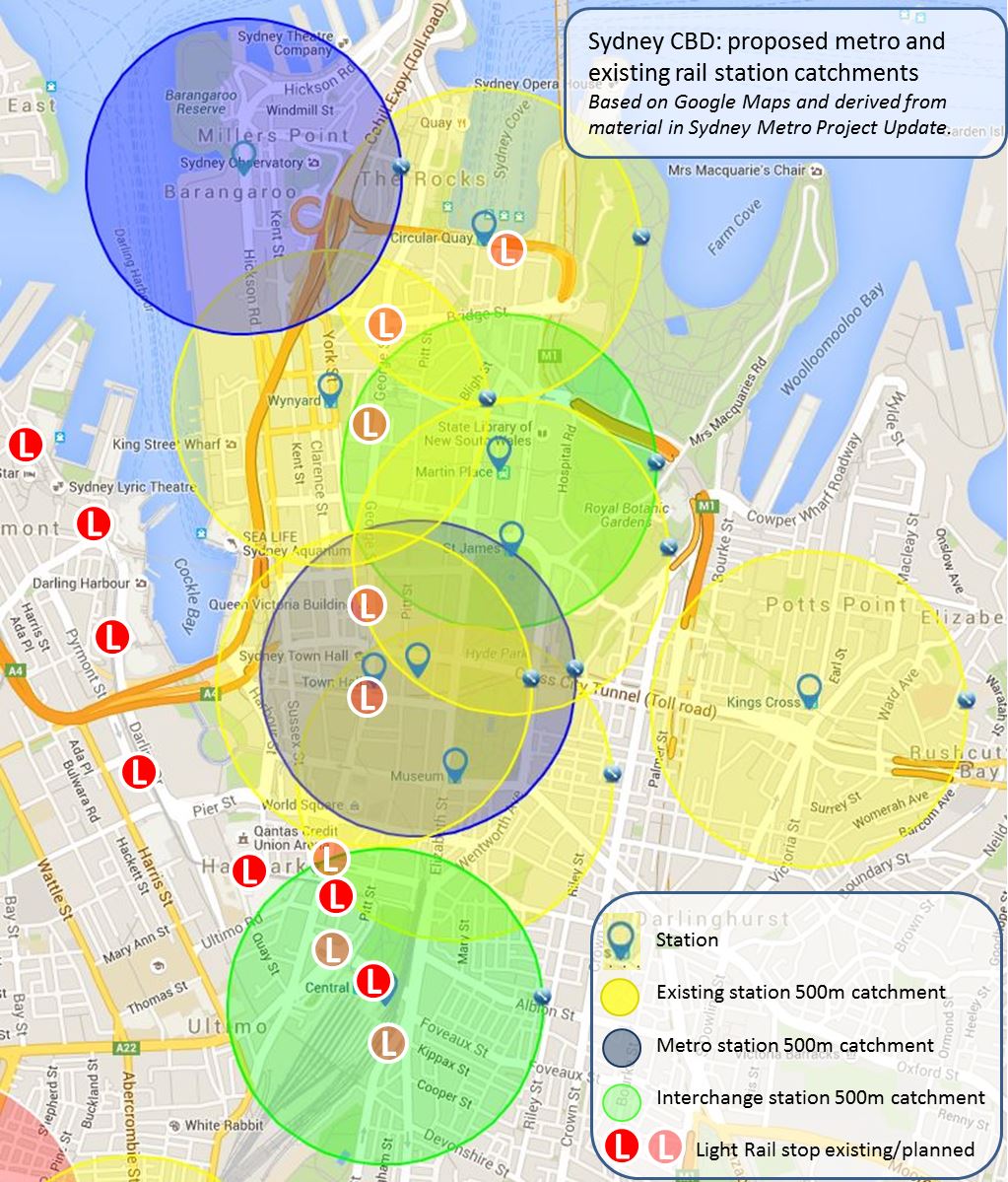
How much will the metro really contribute to Sydney’s peak hour train capacity?
SMH report Jacob Saulwick has questioned the NSW Premier’s claim that the when completed the Sydney Metro will boost the capacity of Sydney’s rail network by 60%. In a recent article Saulwick admits that it was probably “a failure of the media” that he and other journalists did not fully scrutinise this claim at the time it was first made by Mr Baird, partly because the need for an additional line had been “well established for decades” and also because the state government was “making impressive construction progress” on its rail projects.
Since then Saulwick has been attempting to use FOI requests for material that would support the 60% claim. An initial requests for the 2014-15 period revealed none, while a request covering earlier years produced only one document which provides little detail to support the claim. As a result Saulwick states that he has “oscillated between a couple of attitudes” towards the Premier’s commitment and the metro project generally – on the one hand a new line is being built which will greatly increase capacity, on the other the need to justify $10 billion in public spending especially when two existing lines will be “cannibalised” for the project.
“I don’t have a problem with companies running transport services. But the problem is when transport services are structured in a way to make it easier for companies to build and run them, at the expense of what is best for people who need to use them”, Saulwick says, noting that the metro will join the Bankstown line, the least busy of Sydney’s main rail lines.
He concludes by noting the Transport for NSW had subsequently provided some information, claiming that the new metro will add 60 services to the 120 entering Sydney in the morning peak hour. Saulwick suggests that this does not take into account the 16 services already running in this period on the Bankstown Line, “so the 60 ‘new’ services would really be only 44 – and that’s less than a 40 per cent increase.”
A separate comment piece will be published shortly on this issue.
Transport: Light Rail
Passionate protests fail to save trees from the chop for the light rail
Protestors chained themselves to trees in a desperate attempt to save them from being chopped down to enable construction of Sydney’s light rail line along the edge of Centennial Park. The line was originally planned to run along the south side of Alison Road next to the racecourse but was subsequently shifted to the north side next to the park. The affected trees, some up to 100 years old, were described as “having irreplaceable heritage and environmental value”.
The protest was to no avail however, with most of the trees cut down over a weekend after police told the protestors to leave as they were trespassing. Transport for NSW rejected claims by Randwick Council that it had not been consulted regarding the altered plans, stating that the alignment was changed “after further consultation was carried out with the community and stakeholders” and that the constructing the line on the south side of Addison Road was “unfeasible”. Between two and eight trees will be planted to replace each tree removed.
Gold Coast Light Rail on the up and expanding, as fare increase deferred
Gold Coast Light Rail patronage has increased by 640,000 trips or nearly 52% to a total of 1.88 million fares during the July to September quarter of 2015, compared to 1.24 million trips in the same period in 2014, according to the latest figures from the latest TransLink Tracker report on public transport patronage in Queensland.
While there were increases across all modes of 3.1% in trip numbers to 47.09 million, the new light rail line made the largest contribution of any mode to the 1.42 million extra trips made. The Queensland Minster for Transport Stirling Hinchcliffe claimed in a media release that the Labor government’s decision to reinstate TransLink Tracker was “about restoring accountability and transparency in our public transport network” after the quarterly statisitcal report was scrapped by the previous LNP government.
“It’s fantastic to see that after three years of stagnating under the former government’s watch, patronage on our public transport network is growing and is up by 3.1 per cent,” he said. The Minister conceded however that “affordability remains the weakest performing category”, stating that the Government had appointed a taskforce to review Translink fares. He also announced a fare freeze would be imposed until July 2016 while the review is underway.
In a separate statement Mr Hinchcliffe announced that the three companies short-listed to construct the 7.3 kilometre second stage of the light rail had all submitted detailed bids. GoldLinQ Chairman John Witheriff said the team would now evaluate the detailed proposals with the announcement of the successful tenderer due to be made by April. The project which will link the current northern terminus at Gold Coast University Hospital to the Helensvale rail station and bus interchange is due to be completed in late 2017 or early 2018, in time for the 2018 Commonwealth Games to be held on the Gold Coast.
Light rail to Auckland Airport “a bad idea”
An editorial in the New Zealand Herald has criticised suggestions that light rail could be an alternative to heavy rail for the proposed link from Auckland’s CBD to the city’s airport at Mangere, describing the proposal as “a bad idea”.
The paper’s comments came after the airport’s managing company requested a decision on the mode be made by the middle of the year so that a station can be incorporated into its plans for a new domestic terminal.
“The ability to greet or farewell travellers at Britomart [the city’s current rail terminal] may be more convenient than driving all the way to Mangere for many Aucklanders. For that very reason a rail connection to the airport should be a high priority for the Auckland Council, as it was until, inexplicably, Mayor Len Brown postponed it to the 2020s in his planning.”, the NZ Herald states.
Auckland Transport (AT) is considering both light and heavy rail options, claiming that a heavy rail link would cost around NZ$2.2 billion and provide travel times between the current rail terminal and the airport of 39 minutes while light rail would cost less than half at $1 billion but take five minutes longer (44) minutes to complete the trip. The NZ Herald acknowledges that light is better than the “rattling old trams of distant memory”, but still doubts the travel time estimates because of the impacts of traffic congestion. It concludes that “the airport company envisages an underground station in the new domestic terminal. That sounds perfect. AT should forget about trams and get real trains in there.”
Transport: Rail
Brisbane’s Moreton Bay line “switched on” ahead of mid-year opening
A joint statement by the Queensland Deputy Premier and Minister for Infrastructure, Local Government and Planning and Minister for Trade and Investment Jackie Trad and the Minister for Transport and the Commonwealth Games Stirling Hinchliffe has celebrated the switching on of power for the overhead wiring on the new Moreton Bay line north of Brisbane.

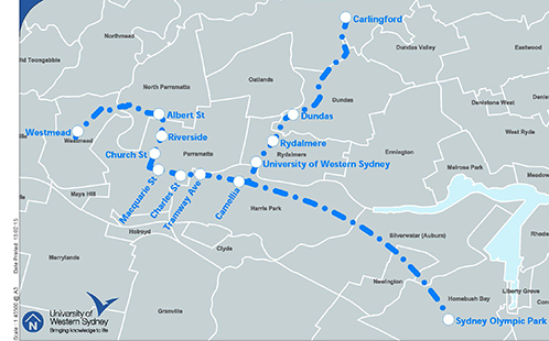
Moreton Bay rail link map (source: Queensland Government website)
The six-station 14km link was jointly funded by the Australian Government ($583 million), the Queensland Government ($300 million) and Moreton Bay Regional Council ($105 million). It runs from Lawnton to Kippa-Ring with a grade separated rail connection to the Caboolture line and is due to open in the middle of the year.
“Once opened, the rail line will revolutionise public transport in the Moreton Bay Region, delivering more than 650 train services between Kippa-Ring and Brisbane each week,” Mr Hincliffe said.
Auckland City Rail Link to be funded two years early
Media reports suggest that the New Zealand Prime Minister John Key will provide financial assistance to Auckland’s City Rail Link (CRL) two years earlier than expected. The foreshadowed decision is set to be announced on 27 January and follows lobbying by Auckland Council in the wake of soaring public transport patronage particularly on the city’s rail network (as reported in TSW no. 3).
In 2013 the government committed to joint funding for the project but said it would provide its share of the funds in 2020. It indicated however that it would consider an earlier start if rail patronage and employment growth in the city centre reached set targets. Preliminary works have already commenced on the line which will complete a loop under the CBD from the current terminus at Britomart to Mt Eden station, with two new stations to be built under the city centre.
“Sky train” suggested to beat Melbourne’s level crossings
Rebuilding the Dandenong rail corridor in Melbourne’s southeast as viaduct has been proposed as an alternative by a bidder for the project to upgrade the line, rebuild four stations and remove nine level crossings, according to media reports.
The proposal for the city’s busiest rail line has been attacked by the Shadow Planning Minister David Davis. “The complete structure of the elevated rail, including poles and overhead wires, will be around three to four storeys high, making it a visual eyesore in suburban areas,” Mr Davis is quoted as saying.
However Ian Woodcock, an urban design lecturer at RMIT, said that an elevated rail line could be a less intrusive way to remove the level crossings than the current method of digging a long trench. Elevated rail lines already exist in some corridors in Melbourne.
Melbourne public transport goes 24 hours while Bendigo gets extra services
Victorian Minister for Public Transport Jacinta Allen has praised the work of public transport operators after the first weekend of Night Network, claiming that almost 10,000 Victorians used the all night services. Night Network is a year-long trial to evaluate the demand for all night public transport at weekends and the impact it has on businesses and residents. During the trial data will be gathered on patronage, network performance data, and public and business feedback.
“Initial myki touch on data from the first weekend has shown three times as many people used Night Network compared to NightRider services – but we want to see even more Victorians taking advantage of this great new service,” Ms Allen said.
In a separate release Ms Allen also released details of the additional services to serve Bendigo. These include an addiitonal morning and evening service between the inland city and Melbourne and more trains will stop at the nearby towns of Epsom, Eaglehawk and Kangaroo Flat. These services will form the first stage of the Bendigo Metro Rail project, which aims to establish a commuter rail service for the city, and are supported by additional bus services.
Transport: Fares and Funding
More support for value capture approaches to fund public transport…
The Committee for Sydney has released a report on how value capture could be used to contribute to public transport funding. While it is focused on Sydney, the the Committee claims the report “also provides lessons for Australian State and Federal governments on how to deliver better transport infrastructure”. The issues paper notes that Public Transport in Australia does not fund itself, with (for example) only 25% of the operational costs of Sydney Trains covered by income and the remainder by general revenue. The report claims this gap needs “to be reduced to make it more viable and attractive to Treasury and Government”.
Lincoln Leong, the CEO of MTR which currently runs the Melbourne Metro rail network and will be the operator of the Sydney Metro Northwest line, is seeking to build and run additional lines in Australia using its version of the value capture model, according to a recent report. “The company funds the construction and maintenance of its rail lines by developing and managing high rise apartment blocks, malls and offices around or on top of train stations and depots,” the article states.
One area of criticism is that the MTR’s Hong Kong developments are very large and dense by Australian standards, which is acknowledged by Mr Leong. “The issue for Hong Kong is we have a relatively large population packed into a relatively small area and therefore inevitably one of the options for us would be to go up, but that need not be the case in other cities and that really is dictated by the city planning,” Mr Leong said.
… but what are the real consequences of privatisation?
While the value capture mechanisms mentioned above can be used by public transport operators, the MTR model provides an example of their use by the private sector. An opinion piece in the Guardian has provided a critique of the privatisation of public transport particularly in NSW – and also of the MTR value capture approach.
In a strongly-worded article, Greens NSW MP and spokesperson on multiculturalism and transport Mehreen Faruqi claims that the “outsourcing and privatising of government services is at the heart of the neoliberal agenda; it’s a test of economic conservatism and ‘management’ to put as many publicly operated services into private hands as possible.”
“…public transport privatisation is the unexamined trajectory of Baird’s overall multi-billion dollar infrastructure strategy – taking our essential transport services out of public hands and into the control of private companies,” she states.
Ms Farudi also singles out value capture for criticism, claiming “big business” also benefits from the resulting “massive overdevelopment” around stations. In addition she argues that “carving up” the rail network “is a way of breaking down an organised and unionised workforce” and is also critical of the privatisation experience in Victoria.
“Melbourne trains are run by MTR, which is often exemplified for running the supremely efficient Hong Kong Metro. This is the company the government has brought on to run metro trains in Sydney. But MTR is owned by the government of Hong Kong, and when MTR ventured into the world of private contracting for running Melbourne’s public transport the successes of Hong Kong could not be replicated.
“The vague myths about private operators reducing costs and increasing efficiency are just that – myths”, she states.
Most NSW paper tickets phased out – and the possible end of cheaper Opal travel
The sale of most NSW public transport paper tickets including pensioner excursion tickets, bus and ferry TravelTen tickets and rail MyMulti weekly tickets ended on 1 January 2016. The only remaining paper tickets are adult and concession single and return tickets and some pensioner country and international student tickets.

Meanwhile the NSW Independent Pricing and Regulatory Tribunal (IPART) has released the More efficient, more integrated Opal fares draft report. In a media release accompanying the report the IPART Chair Dr Peter Boxall said the proposals “are designed to deliver a fairer structure of fares, while ensuring fares continue to cover approximately 20% of around the $6 billion1 cost of providing public transport”.
Dr Boxall stated that the proposed changes would mean that over 60% of passengers would pay less next year and that over the next 3 years, the average annual increases before inflation would range from 1.8% for rail passengers, to 3.3% for bus and light rail passengers, and 3.5% for ferries.”
The review also proposes ending the multiple flag falls which still apply under Opal for mode changes on a single trip.
“The package we’re proposing would make public transport fares more integrated by calculating fares for multi-mode journeys in the same way as for single-mode journeys, so customers could switch modes without being penalised”, Dr Boxall said.
There would also be a bigger discount for off-peak rail travel – but longer distance journeys would become relatively more expensive. What has been described as the “Opal loophole” – the practice of some passengers who take short, unnecessary trips early in the week in order to qualify for free trips on their actual much longer commute would also be ended.
“We are also proposing to reduce the number of free trips enjoyed by some, so more passengers can access lower fares without further increasing the burden on taxpayers,” Dr Boxall said.
Submissions on the draft report will be accepted until 5 February 2016, with the intention that new fares would come into effect on 1 July 2016


 The map above shows Sydney’s current orbital corridors as well as the current and planned radial ones (I have used a slightly out-of-date Transport for NSW map as my base and my additions should be regarded as indicative rather than accurate). The orbital links are numbered from the CBD outwards and the first orbital link (no. 1a) is the most recent – the section of the inner west light rail extension that runs more or less north-south between Lewisham West and Dulwich Hill station, though the former interchange requires a 300-metre walk to Lewisham railway station.
