In 2018 I published a series of articles speculating on the likely route and station locations for the proposed Sydney West Metro. In the final article I concentrated on the CBD, commenting that geotechnical investigations for the project may provide some clues regarding potential station sites.
That work has continued, and now the Sydney Morning Herald has mapped many of the locations where geotech activity has taken place, revealing areas of concentrated investigation along the route. Meanwhile the Minister for Transport has indicated that there will be a maximum of nine stations.
While there have been no formal announcements regarding specific locations, the options seem to be narrowing. They suggest that my previous comment that Martin Place station could become the “new” Sydney Central could well be an understatement, with an underground walkway set to provide a potential corridor across the CBD, potentially linking up to five CBD metro and rail stations.
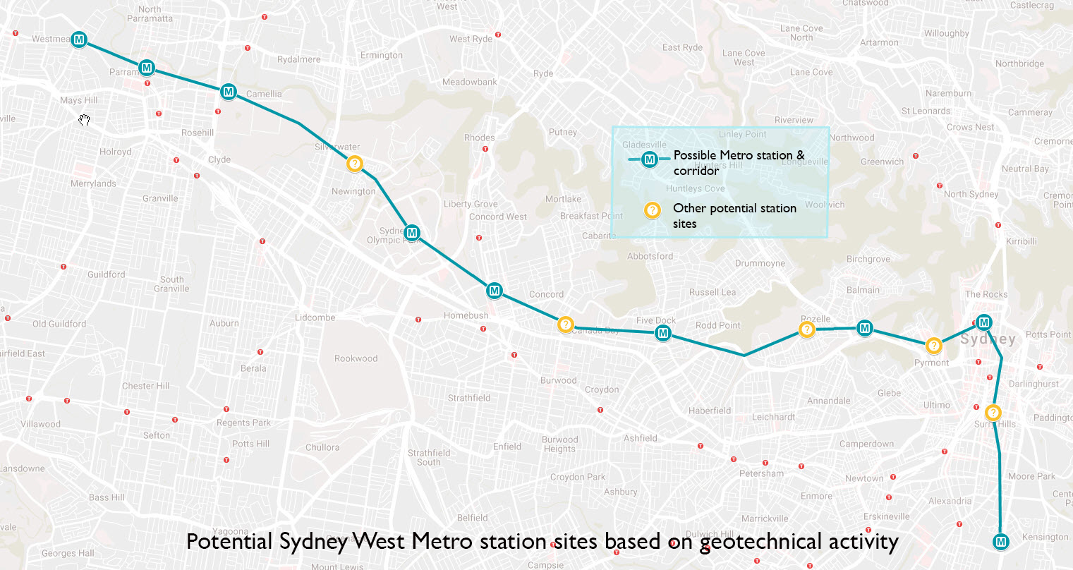
Sydney West Metro Potential Route and Stations. Sources: Transport for NSW geotechnical location data, SMH, Google My Maps
Background
I’ll return to the implications of this in a moment, but first a brief recap. The NSW government is planning to build a second driverless metro line between Westmead, Parramatta and the city which is scheduled to open in the late 2020s. The metro will help relieve the current heavy rail line which is at capacity in peak hour, as well as “unlocking housing supply and employment growth between the two CBDs”.
Depending on the corridor chosen and the number of stations, the route would be 20 to 25km long, while the government is aiming for a journey time of less than 20 to 25 minutes. The government has committed to stations at Westmead, Parramatta, Sydney Olympic Park, an interchange at a station on the T1 Northern rail line, The Bays Precinct and at least one station in the CBD. It is also investigating additional station locations and the potential to extend the metro to the southeast of the city through Zetland.
The SMH article has used the location and intensity of geotechnical survey work to map a probable route and potential station sites. This data has to be treated with some caution; as the SMH report notes, Transport for NSW has warned that high levels of geotech activity may just be “filling in the gaps” of existing geological information.
However, it seems highly likely that the areas which have come under the most scrutiny are those with the greatest potential to become station locations. Conveniently for the government’s planning strategies, many of these locations also offer opportunities for redevelopment as residential or employment centres.
What does the geotechnical work reveal?
Based on these considerations, it’s possible to get an idea not only of the suburbs that will receive metro stations but also quite specific locations for them. Starting from the west these are:
Westmead: The government has always been committed to a station in the Westmead precinct because of the area’s hospitals and other medical services. However, investigation has been concentrated closer to the existing railway station than the hospital, making Westmead the most likely location for the metro’s major interchange with the T1 Western Line.
Parramatta: One of the project’s core precincts, the block bounded by Church, Phillip, Smooth and Macquarie Streets has received the most attention. While this location would offer a good interchange with the under-construction Parramatta light rail, it is at least 200m from the existing station. This tends to confirm Westmead rather than Parramatta will be the location of the interchange.
Camellia: The Camellia/Rydalmere area was nominated as a potential site for an additional station. Investigations have taken place near both Camellia and Rydalmere stations. The former has received more attention and appears to be favoured over Rydalmere because this would avoid the need for a river crossing. Camellia is also the location of the Parramatta light rail depot and the Minister has previously indicated that this is the preferred location for the metro stabling yard.
Sydney Olympic Park: Originally identified as a core station location, geotechnical investigations have been carried out close to and south of the existing rail station, suggesting another interchange here with both the existing railway station and the future light rail which will run nearby.
North Strathfield: The government made an early commitment to an interchange with the T1 Northern line. Based on the intensity of the investigations underway, the area around North Strathfield station is clearly favoured over the alternative, Concord West station. This is a surprising choice; North Strathfield is a relatively minor station compared to its immediate neighbours, Concord West and the much larger Strathfield station. However, it is close to Parramatta Road, and this location may offer greater redevelopment opportunities as well as the potential for a bus interchange. Investigation has concentrated on the area immediately east of the existing station.
Five Dock: The Five Dock/Kings Bay area is another area identified for a potential metro station. However, there has been no geotech activity at all around Kings Bay, while investigation has been quite intense in Five Dock. This has concentrated on the Five Dock shopping centre on Great Northern Road.
The Bays Precinct: A core station location, the investigations have centred on the western end of White Bay, near the decommissioned power station. While this would be central to the redevelopment area, the question of providing transport within the wider precinct remains unresolved.
Sydney CBD: Obviously, the location of the Sydney City station is a critical component of the project. It was widely expected that the station would be collocated with the station on the Metro City and Southwest line which is to be constructed close to the existing Martin Place station on the Eastern Suburbs line. The government had also indicated that a pedestrian tunnel would link these stations to Wynyard Station on the western side of the City Circle.
However, the geotechnical investigations suggest a different approach. It appears the station will be placed under Hunter Street, roughly equidistant between Wynyard and Martin Place stations and linked to these stations by the planned walkway.
Zetland: As I commented in my last article, tunnel boring machines (TBMs) require either massive shafts or dives (tunnel entrances) for installation at the beginning of the tunnelling process and retrieval at the end. It would be extremely difficult to excavate such entrances within the CBD, so if the government is planning to extend the metro to the southeast via Zetland this would be a logical place to put such an entrance and, ultimately, a station.
This would be consistent with the government’s plans for major redevelopment in the Waterloo/Green Square/Zetland area. The investigation has concentrated on the area around the intersection of Epsom Road and the Eastern Distributer, roughly equidistant from Green Square station (1km to the northwest) and the Todman Avenue light rail stop on the CBD and Southeast Light Rail (CESLR) line currently under construction (1km directly east).
Are there any other potential station locations?
Apart from the places which were specific alternatives to the apparently-favoured station locations as listed above there are several other areas between these locations in which investigations have been conducted. These areas could be under scrutiny simply because of geotechnical issues along the metro corridor, or, possibly, as additional station sites – though it is extremely unlikely that more than one or at best two of these locations would be selected.
These sites include a 1.5km stretch from Silverwater southeast to Newington, in Concord near the Parramatta Road/Burwood road intersection, in Rozelle near the Balmain Road/Alberto Street intersection, and in Pyrmont near the Pyrmont Bridge Road/Edward Street intersection.
Intriguingly, although both my previous post and the SMH article speculated on the likelihood of a station in the Central/Surry Hills area, no geotechnical work has taken place here or anywhere else along the five-kilometre stretch from Martin Place/Hunter Street to Zetland.
The new “Super Central”?
The proposed CBD underground walkway will itself become a piece of critical infrastructure, providing an interchange between four stations – Wynyard (City Circle and the Northern/Western lines), Hunter Street (Sydney Metro West), Martin Place (Metro City and Southwest) and Martin Place (Eastern Suburbs/Illawarra). A fifth City Circle station could be added; the Minister has suggested previously that the proposed project to seek interest in redeveloping the unused tunnels north of St James station could incorporate a connection from St James to Martin Place.

Potential City Interchange Walk. Sources: transport for NSW geotechnical location data, SMH, Google My Maps
This could have significant implications for both demand levels at city stations and pedestrian movement generally around the city. Clearly the government is trying to take some of the pressure off the overcrowded Town Hall Station, which won’t have a direct link to either metro line, by encouraging changing at either Central or the new Wynyard/Hunter Street/Martin Place interchange.
However, the proposed walkway from Wynyard to Martin place would be almost 600 metres in length; if Hunter Street is confirmed as the new location for the Sydney West Metro CBD station it would be around 250 to 300 metres from either station. This would mean that there would be no short-distance interchange between the Sydney West Metro and any other metro or rail line in the CBD.
This scenario increases the likelihood that there will be an additional CBD station to provide such a direct interchange. In the absence of any geotechnical work the following is purely speculative, but two possibilities suggest themselves; Pitt Street, which would provide interchange with the Metro City and Southwest line station being constructed here, and Central, which would provide an interchange with not only this metro line but also all rail lines (my other suggestion, Surry Hills, is less likely as that would require a walk to interchange about as long as that proposed at Hunter Street).
Zetland and beyond?
A station at Zetland would lead to the slightly bizarre situation of five separate rail, metro and light rail stations in a disconnected four-kilometre arc running southeast from Redfern to the University of NSW – Redfern, Waterloo, Green Square, Zetland and the University of NSW – an average of a kilometre or less apart, and servicing five separate lines.

The Southeastern Arc – Redfern to the University of NSW. Sources: Transport for NSW geotechnical location data, SMH, Google My Maps
While the additional rail capacity is consistent with the government’s plans for major residential redevelopment in this area, this approach suggests a piecemeal approach to planning the infrastructure required. This is highlighted by the lack of any plans to provide a metro or even a light rail line to the University of Sydney just to the east of Redfern, despite it being a major source of transport demand. It should be noted that if Labor wins the upcoming NSW election, they have committed to investigating station options near the university and the adjacent Prince Alfred Hospital.
Another shortcoming is the lack of certainty regarding the terminus for the metro. While the government has hinted that it may be extended as far as Malabar, at this stage no geotechnical work has been conducted beyond Zetland. This leaves the metro a frustrating one kilometre short of a potential interchange with the CESLR at the University of NSW. Such an interchange would greatly relieve pressure on the light rail, which projections suggest will be running at capacity from the first day of operation in 2020.
Unfortunately this possible outcome would be consistent with the government’s lack of interest in extending many of its current and proposed rail projects the comparatively short distances required to link them to existing rail infrastructure, for example, the Metro Northwest’s failure to link to the Riverstone line, or the Parramatta Light Rail falling short of a link to the Northern rail line. The government’s commitment to the construction of rail infrastructure is to be applauded but failing to join all the dots on rail transport significantly reduces the effectiveness of these projects.

Pingback: Update: Sydney West Metro station plans firm in NSW election refresh | StrategicMatters
Pingback: Sydney Metro West update: the government goes for speed over coverage | StrategicMatters
Pingback: Sydney Metro West gets a mega CBD interchange and Star Casino hits the jackpot, but no southeast link | StrategicMatters