It’s always easy to know when there’s an election on the way in Australia, especially in NSW, as all parties commit to new projects big and small. Top of the list are new infrastructure projects – hospitals, roads, and, increasingly, public transport – with their seductive promise of a shiny new future, ushered in by ribbon-cutting politicians.
But what if you are in government and have already started planning or constructing several large infrastructure projects, or you are in opposition trying to differentiate yourself while supporting at least some of the government’s proposals? Well, the next best thing to a new project is to “refresh” an already-announced one, for example by proclaiming that extra funding has been earmarked for it, that work will begin sooner, or that it will be “fast-tracked” – even if the project remains largely unchanged.
Recent announcements about the Sydney West Metro by both major political parties in the run-up to the 2019 state election provide excellent examples. A few weeks ago NSW Opposition Leader Michael Daley’s committed to spend $8 billion to “fast-track” the planned line. In the last couple of days the government responded, with the NSW Premier Gladys Berejiklian and Transport Minister Andrew Constance announcing that $6.4 billion would be set aside for the project and that construction will begin a year earlier than previously planned, in 2020. The premier also committed to reducing journey times between Parramatta and the city via the metro to around 20 minutes.
Despite all these promises it is unlikely that the project will be completed significantly earlier than 2028 – and neither the government of the opposition’s funding announcements will be nearly enough to complete the metro, given its $16 billion estimated cost. However, the announcement did provide more details regarding the government’s proposed route and preferred station locations, coming shortly after the Sydney Morning Herald’s documentation of the sites of intensive geotechnical investigations for the project and my most recent article which used this information to try to assess the most probable corridor.
While they have both refreshed their commitments to the project, the announcements mean there is now some differentiation between the parties in their approach which have some interesting implications.
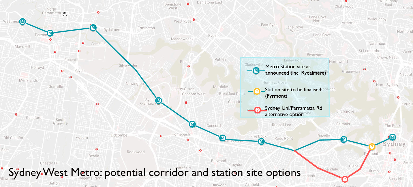
Sydney West Metro: potential corridor and station site options. Sources: Transport for NSW, SMH, Coalition/ALP statements, Google My Maps. (Map assumes Rydalmere corridor is selected).
The Coalition – an earlier start date and a Rydalmere surprise
As already indicated, the government has committed $6.4 billion to the project which it intends to start building in 2020. It has also committed to a 20-minute journey which has clearly influenced the final decisions about the route and the location and number of stations.
A comparison between the government’s statement and my recent speculations based on the geotechnical surveys shows a degree of consistency, at least at the suburb level. The statement confirms the previously announced stations at Westmead, Parramatta, Sydney Olympic Park, North Strathfield, Burwood North, Five Dock, the Bays Precinct and the CBD.
Out of these stations all but North Strathfield and Burwood North were identified early in the project’s development. There was also an early commitment to an interchange with the Northern Line, but the geotechnical data suggested that North Strathfield would win over the three other options – Rhodes, Concord West and Strathfield.
In my last article I noted that the geotechnical investigations suggested other possible sites, including Burwood North, which has been selected, and Rydalmere and Pyrmont, both of which are still under consideration. The biggest surprise is that Rydalmere appears likely to be chosen over Camellia, which was my suggestion based on the geotechnical work, the fact that the latter station would have avoided two river crossings and also the potential to build stabling facilities there. The Camellia option also offered the most direct corridor. Rydalmere would however still provide an interchange with the about-to-be-constructed Parramatta Light rail line and is next to a major Western Sydney University campus.
The only other station issue yet to be finalised is whether there will be one at Pyrmont. In summary, the Coalition has committed to an eight to 10 station corridor with travel times from Parramatta to the Sydney CBD of around 20 minutes, with construction starting next year and a completion date of 2028. However, no information about the route east from the CBD has been announced, nor has the government clarified where the remainder of the $16 billion budget for the project is going to come from.
Labor – fewer road projects to fast-track funding
The NSW Opposition Leader’s earlier announcement included a commitment to put $8 billion towards the project. This would be funded in part by cancelling a number of the government’s motorway project proposals including the Western Harbour Tunnel and Beaches Link toll roads, as well as the F6 extension.
If it wins office the opposition has also committed to cancelling the Bankstown Line conversion which forms part of the Sydney Metro City and Southeast currently under construction. Mr Daley’s funding commitment also includes $3 billion already committed to the project by the federal opposition, should they win the federal election.
Mr Daley did not detail how and to what extent the project would be accelerated, but he said that if elected Labor would “at least match” the state government’s projected completion date. Mr Daley also did not indicate if the opposition would stick to the government’s commitment regarding travel time or its preferred route, though significantly about six months ago Labor’s transport spokeswoman, Jodi McKay, said the opposition was “not wedded to a journey time of 20 minutes”. She suggested at the time that the priority was providing public transport and addressing the issues along Parramatta Road, also indicating a potential stop at the University of Sydney rather than the Bays Precinct should be “in the mix”.
Key differences – and similarities
Funding: Labor has promised $8 billion for the project compared to the government’s commitment of $6.4 billion, though this includes $3 billion that is dependent on the election of a federal Labor government, as well as contributions from the other transport projects it would cancel. Neither party has identified how the remaining shortfall in the metro’s projected budget of between $10 and $11.4 billion will be funded, though there could be some additional savings for Labor from the cancelled road projects.
Completion date: Despite the commitments from both sides to speed up the project, it seems unlikely that it will be finished much earlier than the current estimated completion date of 2028.
Route and speed: The government has confirmed it prefers speed over than coverage with a limited number of stations and a fairly direct route, excepting the probable deviation via Rydalmere away from the shorter corridor through Camellia. The resulting route will be around 23 kilometres long; a trip time of 20 minutes to Parramatta would mean a relatively high average speed including stops of nearly 65km/h, slightly faster than the Sydney Metro Northwest projected speed of 60km/h.
There will be between eight and 10 stations, resulting in a comparatively high average station spacing, even by modern metro standards, of between 2.5 and 3.3km. In addition, the stations will not be evenly distributed; there will be two large gaps of around four to 4.5 kilometres each between Rydalmere and Sydney Olympic Park and between Five Dock and The Bays Precinct. These gaps will separate three sets of stations which are more closely spaced – Westmead to Rydalmere, Sydney Olympic Park to Five Dock, and The Bays Precinct to the CBD.
As noted earlier, Labor has not commented specifically on the route, except for Ms McKay’s response a few months ago regarding the need for the metro to provide greater public transport coverage rather than speed, especially of Parramatta Road and, possibly, the University of Sydney.
Comment
Both parties’ recommitment to the Sydney West Metro means that it will almost certainly be constructed after the election. The remaining differences reflect varying philosophies; the government has made quick travel times between Parramatta and the city a high priority, turning the metro into a high-speed limited stop service which will service selected centres along the corridor, some of which offer redevelopment potential.
Meanwhile, the Opposition’s approach seems to emphasise a more even distribution of stations to provide additional public transport along Parramatta Road and other areas which are heavily reliant on buses. The trade-off for this more conventional approach would be slightly longer journeys, though sub 25-minute times still seem feasible.
Labor has a dilemma here, however – radical changes to the route could require extensive resurveying of the whole corridor, potentially affecting the commitment to fast-track the project. It is therefore likely that if the party wins the election it will look at accepting the route largely as announced by the current government, but possibly adding extra stations in the gaps previously discussed. One major difference would be if Labor decided to prioritise the University of Sydney, Prince Alfred Hospital and Parramatta Road by shifting the eastern end of the metro route southward away from The Bays Precinct (shown in red on the map). Depending on the corridor selected and specific station locations, this would add about 1.5 km to the length of the corridor and about 1.5 minutes to the length of the journey.
Finally, both parties have been largely silent about any plans they may have to extend the metro, beyond the government’s commitment expressed in the Sydney Metro West Project Overview that it will “safeguard the ability to extend Sydney Metro to the south-east of the Sydney CBD via Zetland, serving the Green Square town centre, as well as towards the west beyond Westmead – where one option would be to the new Western Sydney Aerotropolis”. I discussed some of the eastern options in my last article on the metro, and I will revisit these and potential extensions to the west in a future post.

I was hoping against all hope (ever since Morris Iemma first drew a dotted line through Drummoyne over ten years ago) that this latest version would come closer to me, but Five Dock is still ok – a 20 min walk, 5 min by bus. I live near Iron Cove and received a flyer in the mail recently announcing geotechnical testing a bit north of the route shown on your map – actually in the water (or sludge – its hard to call the upper reaches of the Iron Cove anything else). They plan to be drilling directly in front of Le Montage in Lilyfield, and then in another water site west of the UTS Rowers. If that is the trajectory of the route, I might get lucky and get a station approximately on the corner of Lyons and Great North Roads.
But having so few stations and often so far apart will one day be seen as a huge lost opportunity. Jacob Saulwick in the Herald brought this up last weekend too – he just simply had to to find something wrong with what he admitted at the outset “will be of huge benefit to Sydney” (Is that the first time the Herald has ever said that?! How strange… An astonishing admission for them. But then, only one sentence. The rest of the article was typical Herald – gloomy, negative spin).
https://www.smh.com.au/national/nsw/railroads-parading-as-metros-the-long-and-short-of-sydney-rail-maze-20190307-p512h3.html
But it is fair point – the west metro could have had more stations – like at the northern end of Norton St to interchange with the light rail, and further west too. The 20 minute trip (or less) to Parramatta could be done an with express service, with a “local” stopping more frequently – as they do on many of NY’s equally long subway lines. If as suggested, a Hong Kong-like “value capture” model is applied – paying for the (admittedly expensive) stations shouldn’t be a problem. I know the government of the day (whoever it is) will have to endure endless handwringing “high rise horror” stories in the local press (and the Herald). But support amongst nearby property holders and local home owners themselves would most likely be high, especially when they understand how much proximity to the metro will make their assets worth.
In a time of declining property prices, even the Herald might be able to find something rosy about that… (although probably they won’t).
LikeLike
Pingback: Sydney Metro West update: the government goes for speed over coverage | StrategicMatters