Two more pieces in the Sydney Metro West puzzle were revealed in the recent announcement by the NSW Government of the location of the remaining stations on the line – Pyrmont and Hunter Street. The announcement itself was not a great surprise, as the general location of these stations has been foreshadowed for some time. However, the revelation of their exact locations has several interesting implications.
The first of these is confirmation that Hunter Street Station will play a pivotal role in a mega transport interchange underneath the northern part of the Sydney central business district (CBD). The second is the close proximity of Pyrmont station to the casino and how that may influence the redevelopment of the Pyrmont peninsula, which is similar in some respects to the relationship between Barangaroo station and the partially-opened Crown Casino.
However, one puzzle piece is likely to remain missing indefinitely – an extension of the metro to Sydney’s southeast. This along with several aspects of the metro’s design points to some of the compromises being made in the face of the project’s rising cost.
First, a very brief recap: Sydney Metro West (SMW) will be Sydney’s second metro line, stretching 24 kilometres from Westmead in Western Sydney to the city centre. Station locations have previously been confirmed at Westmead, Parramatta, Sydney Olympic Park, North Strathfield, Burwood North, Five Dock and The Bays.
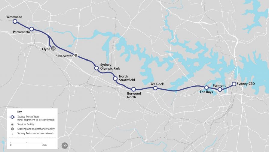
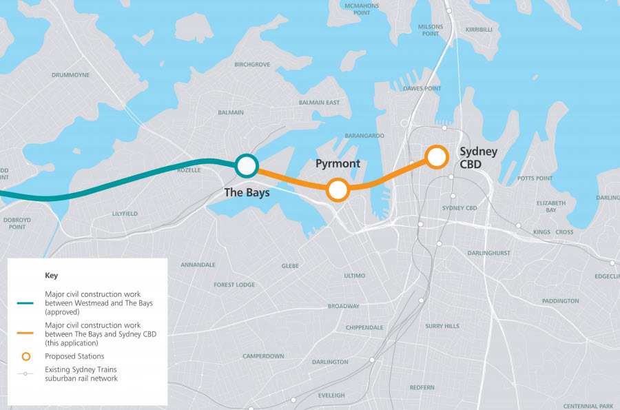
The final route and station options are fleshed out in more detail in two just-released scoping reports for the project; the Scoping Report – Major civil construction work between The Bays and Sydney CBD and the Scoping Report – Rail infrastructure, stations, precincts and operations. These provide a clearer picture of the route between The Bays station and the city terminus at Hunter Street.
Hunter Street and the potential for a mega interchange
The civil construction Scoping Report reveals the list of shortlisted station locations considered for the CBD terminal for Sydney Metro West. Apart from Hunter Street, these were Circular Quay, Martin Place, Elizabeth Street and Museum Station. Martin Place, Elizabeth Street and Museum were ruled out as presenting “significant challenges with respect to constructability, operations and/or functionality”. It seems Hunter Strret was chosen over Circular Quay because of the greater number of interchange opportunities it presented.
Some reports suggest that the government initially considered two CBD stations but ultimately opted for only one because of cost. A two-station approach may have involved different criteria, but there have been strong indications for some time that at least one station would be built at or near Martin Place. In a post in 2018 I discussed media speculation that it would a direct interchange with the Metro City and Southwest station currently under construction at Martin Place, which itself will connect to the current Martin Place railway station. This was to have been combined with an unpaid pedestrian concourse linked to Wynyard Station. At the time I commented:
Making Martin Place such a critical interchange station clearly reinforces its role as the “new” Central, one which unlike the actual Central Station really is located in the heart of the city – or at least its financial district.
Subsequent geotechnical investigations indicated that the SMW station would probably be located a little further away under Hunter Street, which is roughly equidistant between Wynyard and Martin Place stations. I noted in a post in 2019 how the CBD underground walkway then proposed to connect all the stations would become a piece of “critical infrastructure”.
However, the announcement of the exact station location and orientation adds an interesting twist. The western end of the station will be located on the corner of Hunter and George Streets, subsuming the block currently containing the underground Hunter Connection which connects Wynyard Station to Hunter Street. The station will run under Hunter and Pitt Streets to another large block to be demolished between O’Connor and Bligh Streets where they meet Hunter Street. This is just a few metres from the northern end of the Martin Place Metro Station.
This location points to one thing – the new SMW station itself will provide the pedestrian link between Wynyard Station and the two stations at Martin Place. The following diagram is my suggestion about how the four stations might be linked, based on the recent announcement.
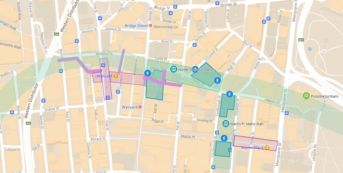
The light purple-coloured boxes and lines represent the existing underground stations at Wynyard and Martin Place, along with the walkways connected to them. The dark green shapes indicate the areas that were either demolished to facilitate construction of Martin Place Metro station, as well as those earmarked for demolition for Hunter Street Metro station.
The lighter green box at Martin Place represents the station canyon for the platforms and concourse currently under construction at Martin Place (please note that this is indicative and not to scale). The positioning of the similar box at Hunter Street is also speculative but seems likely, as it runs under Hunter Street and links the two groups of buildings to be demolished for entrances to the station (the diagram also includes a speculative indication of a possible turnback to the east of Hunter Street station, which I’ll return to later).
How might this work operationally? We know that to the east the link between the two Martin Place stations will be inside the ticketed area, allowing direct interchange between platforms on either line. At the western end, the link between Wynyard and Hunter Street is likely to be at the unpaid concourse level, following in part the route of the current Hunter Connection walkway.
What us unclear is how exactly the two metro stations in the middle, at Hunter Street and Martin Place, will be joined. This link could take the form of a connection at the unpaid concourse level between the stations, effectively extending the unpaid link from Wynyard. Alternatively, it could be a direct interchange within the ticketed area, like that being constructed between the Martin Place stations.
Regardless of how this section is configured there will be a continuous underground pedestrian connection stretching from near Barangaroo via Wynyard to Martin Place, allowing interchange between five stations (as well as the light rail in George Street and the bus services running past Martin Place) via a 600-metre corridor, the core of which will be the two metro stations. As I noted in my earlier posts, this station complex and interchange could become the new de facto “Central” for Sydney’s rail and metro network.
Pyrmont – Sydney’s second “Casino Station”
Over on the Pyrmont peninsula the station will run alongside Pyrmont Bridge Road. The western end will require the demolition of the buildings fronting Pyrmont Bridge Road between Paternoster Row and Pyrmont Street; the eastern end will be under the triangle formed by Pyrmont Bridge Road and Union and Edward Streets. The following again is my speculation on how the station might be arranged.
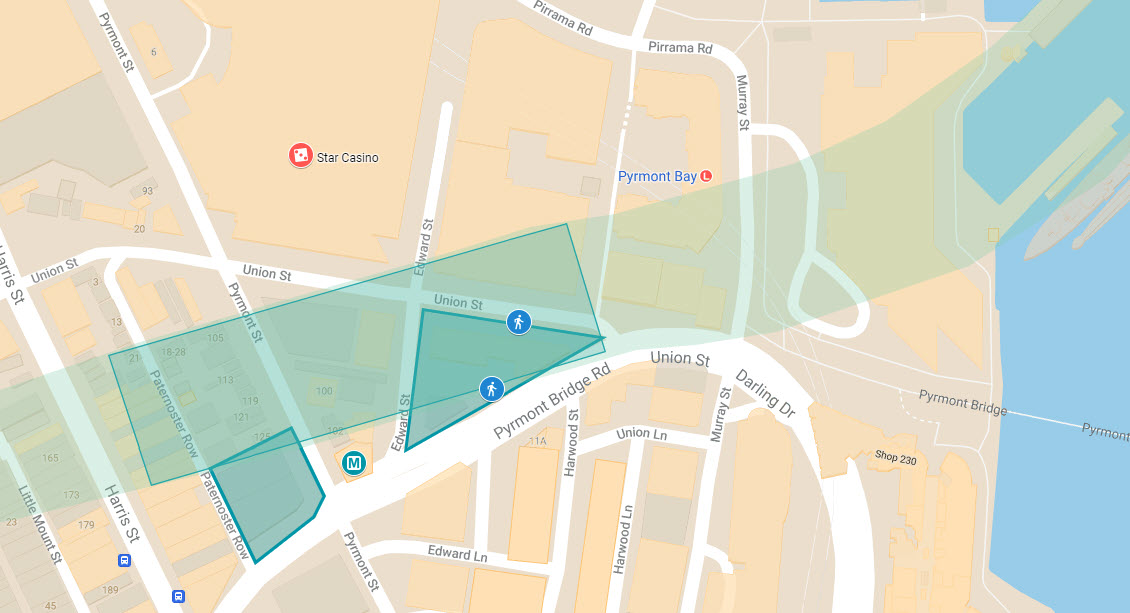
Whatever the internal layout, the station will be literally across the road from the casino which lies just to the north. Star Casino has plans for a 140m tower on this site and claims to have been blindsided by the announcement, which is odd given the government has announced previously it was considering a station in this area. It is hard to imagine that the casino would have a violent objection to having metro station right on its doorstep; much more likely is that the station will be integrated into the casino’s expansion, much as the current light rail station was constructed under the original casino building.
This would also strongly suggest that there will be some form of underground interchange between SMW and the light rail. This is likely to be a significant transport hub as the light rail line runs to Central and the southern end of the CBD; light rail passengers wanting to travel to the northern end of town will be able to change here to get a one-stop ride lasting only a couple of minutes, instead of having to take the long dogleg to Haymarket and changing to another tram there. It also gives light rail passengers wishing to head to Parramatta or Westmead the option of a fast connection via the metro.
The combination of the casino, the potential integration of the metro and the light rail and the proximity of a pedestrian link via Pyrmont Bridge into the city would all support the government’s plans to “revitalise this western gateway to the Sydney CBD”. It also hands the casino the box seat in influencing this process, should it wish to do so. There is an obvious parallel to the relationship between Barangaroo station currently being constructed on the CBD and southwest metro line currently under construction, the Crown Casino and the surrounding development less than a kilometre away on the other side of Darling Harbour.
The end of the line?
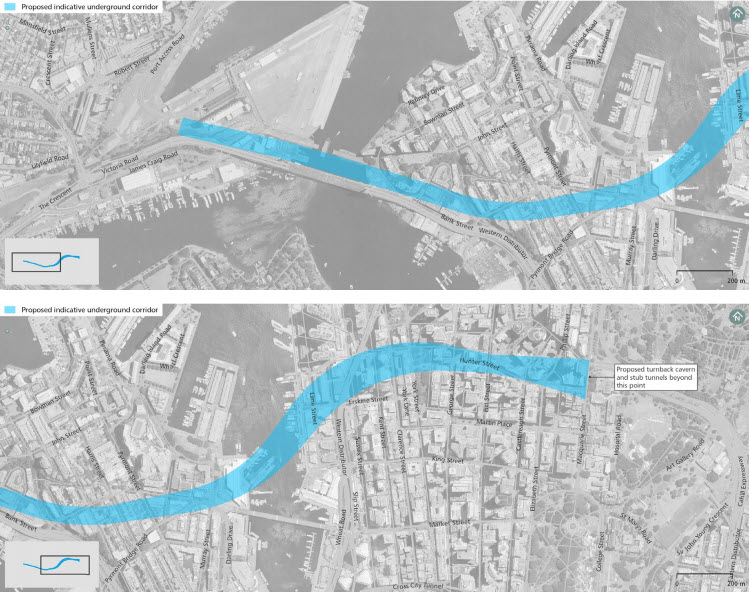
The announcement that SMW will terminate in the city means that the government is passing on the option to extend the line to Zetland and possibly beyond. While this was never an explicit commitment, at least as part of the first stage of construction, geotechnical testing around Zetland led me and others to speculate that this might be the place where the tunnel boring machines (TBMs) might either commence digging the tunnels or be removed at the end of construction. The civil construction scoping report now reveals that the TBMs will be started at the Bays station and will be dismantled and removed at the eastern excavation for Hunter Street station.
That is not the end of the story, however. The terminus will require a turnback for trains to be turned around, much like the temporary one for the metro currently in operation at Chatswood station, or the more extensive one at Bondi Junction on the rail network. It will also include stub tunnels, which will allow the line to be extended in future without disrupting train operations. These are likely to be dug using roadheaders.
What is surprising is how far the proposed location of the proposed combined turnback and stub tunnels is from the Hunter Street station. The indicative corridor for the section of the metro from The Bays to the CBD is shown below; the tunnel extends over 300 metres from the likely eastern end of the station to end just east of Macquarie Street, where the diagram indicates that the turnback cavern and stub tunnels will begin. This is quite different to the arrangement at Chatswood, and will put the turnback and stub tunnels under The Domain, the Eastern Distributor, the State Library of NSW and the Art Gallery of NSW
There may be a simple explanation for this. The SMW line will have to pass under the City Circle, which in this section runs underneath Macquarie Street, as well as a number of high-rise buildings. While the metro tunnel itself will be sufficiently deep for this not to be an problem, the turnback cavern which may incorporate some train storage is likely to be considerably larger. The assumption seems to be that this won’t be an issue for the older buildings east of Macquarie Street.
Comment
The government’s announcement and the subsequent scoping reports flesh out some of the detail for the eastern end of the Sydney West Metro, though it raises as many questions as it answers.
The first is how the mega multi-station interchange planned for the northern CBD will handle the sheer volume of pedestrian traffic to, from and between the different stations. The concept is superficially attractive, but it also represents a compromise in terms of convenience and interchange design which smacks of an ad hoc approach to planning Sydney’s metro system.
The government has always indicated that it wanted to build a second metro line between Parramatta and the city but passed up the opportunity to provide for future fully-integrated interchanges in the design of the CBD stations for the City and Southwest line currently under construction. For example, the station canyons at Martin Place or Pitt Street could have been designed so the two metros could have been stacked on top of each other, even allowing for cross-platform interchanges like those at some stations in Hong Kong’s MTR system.
The government should have also stuck with the original plan to construct two CBD stations to handle future passenger growth despite the cost involved, especially if the SMW line is extended further west to link to the Sydney West Airport or out to the southeast as originally planned. This could have involved either two interchange stations, or an interchange station and a stand-alone one in the southern CBD. This area, in particular the section between Town Hall, Museum and Central stations and encompassing Haymarket and the southern end of the Darling Harbour precinct, will remain much more poorly served by metro or heavy rail services than its northern counterpart.
The decision to terminate the metro in the CBD again due to its increasing cost is also disappointing. The line should be extended southeast to interchange with the light rail line at Randwick or Kingsford and, ideally, an extended Eastern Suburbs Railway. This would alleviate the potential capacity issues on the light rail line once COVID restrictions ease. At least provision has been made for the line to be extended in future, and the construction of a turnback cavern to the east of the CBD under The Domain raises the intriguing possibility that once the line is extended this space could be repurposed as an additional metro station to serve the art gallery precinct and Woolloomooloo.
Finally, there is the location of the metro station in Pyrmont. While this will allow for the extension of the CBD onto the Pyrmont peninsula and for a useful interchange between the light rail and the SMW, it is ironic that a second city metro station will be right next a casino. It seems you have a 100% chance of getting a station on your doorstep if you happen to be a casino in Sydney, which is considerably better than the odds of scoring a station if you are a university.

Has any thought being given to connecting this line to the Eastern Suburbs railway to Bondi Junction & converting it to Metro (as was done from Epping to Chatswood line)? . This would allow trains to turn around at Bondi Junction (although I acknowledge I’m not sure about the capacity to turnaround trains on T4 line from Sutherland). It would also directly connect Parramatta to Bondi Junction.
The great missed opportunity is a station at Camellia. This would service a large new suburb which is to be developed. It would interchange with the new light rail from Carlingford. It would be walking distance to Western Sydney University campus at Rydalmere & also service Parramatta East & Rosehill. There is a stronger case for a station here than some of the proposed stations.
LikeLiked by 1 person
Hi Anthony – and thanks for your comment. I think the government is more interested in extending the line to the southeast, I wrote a couple of articles on this blog a few years ago about the gaps in Sydney’s orbital public transport network; among a few other things I proposed an orbital link from the ESR via the LR and the airport stations to Rockdale or Kogarah and beyond: https://thestrategicweek.com/2015/09/29/getting-around-sydney-why-orbital-public-transport-matters-part-2/.
According to the Government’s South East Sydney Transport Study (https://future.transport.nsw.gov.au/plans/south-east-sydney-transport-strategy) there are long term plans to do something like this, but not as far as Bondi Junction .
Finally, I agree with your comment about Camellia.
LikeLike