
In the first post in this series I discussed the implications of the NSW Government’s recent announcement that the Parramatta Light Rail (PLR) project will be built in stages, with the link to Carlingford being given priority over what is now a stage 2 line through the Sydney Olympic Park corridor which is to be planned in conjunction with the Sydney West Metro.
In the second post I discussed the preferred route, comparing it to one chosen originally by Parramatta Council. In this third article in the series I’ll discuss in more detail the Stage 1 extension option currently under investigation as well as the complexities surrounding the route choices for Stage 2.
Stage 1 extension to Epping
Background: In the wake of the government’s recent PLR announcement, most of the discussion centred on the decision to defer Stage 2. Almost unnoticed in the FAQ section of the PLR site was the statement that “An Epping extension study is being carried out in line with feedback from the community to explore options for this transport corridor.”
The original Parramatta Council report opted for a link to Macquarie Centre via Eastwood instead of the Epping option but this involved deviating from the Carlingford line north of Dundas (Council had left open the question of whether the light rail should take over or sit next to the existing heavy rail corridor between Camellia and Dundas). When the government announced that it would support the concept of a PLR network it became clear that it favoured the conversion of the Carlingford line.
It was assumed that this option was also favoured because it provided the most direct and cheapest option for an orbital link between Parramatta and the North West metro. There was therefore some surprise when the government confirmed last year that the Carlingford line was indeed its preferred option but it had no intention to extend the route any further.
Now an extension from Carlingford to Epping has been put back on the table, albeit only as a study and it would seem largely because of community pressure. No details regarding the study process have been released.
Route options: There is effectively only one option – a four-kilometre run along Carlingford Road between Carlingford and Epping stations. The key questions would be how the light rail would be extended from the Carlingford station terminus on the current rail line, how the intersection of Carlingford Road and Pennant Hills Road/Cumberland Highway would be handled and at the other end how the line would terminate at Epping Station.

Carlingford-Epping PLR link option (underlying map source: Google Maps)
Pros: The extension would provide Parramatta residents with access to employment opportunities around Macquarie Park, and vice versa. It would also provide a significant orbital link between the main western and northern rail lines as well as the metro north west corridor currently under construction.
Cons: There are already congestion issues in this corridor, particularly at either end. It may be that the only viable option at the Carlingford Road and Pennant Hills Road/Cumberland Highway intersection would be grade separation with the light rail in an underpass or overpass. Carlingford Road itself is comparatively narrow and it would be difficult to completely separate the light rail corridor from traffic lanes. Intersections along the route would also require modification.
While joining the link at the Carlingford end with the Stage 1 line would be relatively straightforward, there could be major issues integrating what would be the new terminus at Epping with what will by then be a major transport interchange between the existing rail network, bus services and Sydney Metro North West.
Stage 2 Olympic Park corridor
Background: The government’s decision to defer Stage 2 to plan how it might complement the separately-announced Metro Sydney West line which would run through the same corridor has not only thrown open the route options for this line but also raised the prospect that Stage 2 might be abandoned entirely.
Another factor which is likely to affect both whether the project will proceed and if it does so the final route is the financing of the project, which was to be a mix of government funding and value capture from developments along the corridor. One interpretation of the government’s announcement is that it plans to spend most of its notional $1 billion allocation to the project on Stage 1 (which has limited potential for value capture) while expecting business in the Olympic Park corridor to stump up most of the costs of Stage 2. It has also been suggested that this approach could give the government a handy pretext if it wanted to walk away from Stage 2 by claiming that the value capture contribution would not be enough.
Given this degree of uncertainty any discussion of route options for Stage 2 has to be fairly speculative. The following is therefore a series of (hopefully) educated guesses and draws from my earlier posts in this series as well as my discussion late last year regarding Western Sydney metro options.
Route options: The original PLR announcement was accompanied by an indicative map suggesting the route would run in a southeast direction from the junction with the Stage 1 line at Camellia via Silverwater and Newington to Sydney Olympic Park then via Homebush to an interchange at Strathfield station. This differs from the original Parramatta Council recommendation which was for the line to turn east and eventually northwards to terminate at Rhodes Station on the main north rail line.
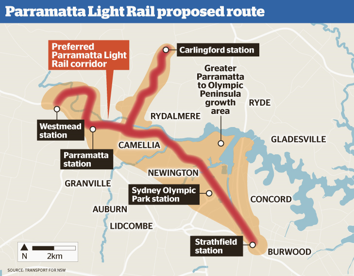
State Government’s 2015 indicative corridors for Parramatta Light Rail (source: NSW Government)
The government’s announcement that Metro Sydney West would also stop at Sydney Olympic Park (SOP) would make this a likely heavy rail/light rail/metro interchange. In addition, as the metro is likely to take the most direct route underground from SOP to Parramatta with possibly only one intermediate station (for example, at Camellia to form another interchange with the PLR) or even none at all, it is quite possible that the light rail could broadly follow the slightly more indirect route shown in the indicative map between SOP and Parramatta but make more stops to provide a finer-grained service in a corridor that is earmarked for major redevelopment.
This option is also suggested by the decision to locate the PLR depot for Stage 1 just off the disused rail corridor east of Rosehill Racecourse; this short 600-metre link would form a logical start for this alignment. From there as Council proposed the line would run via Silverwater and Newington to SOP.
The situation east of SOP is much less clear. The initial proposal as shown in the above map suggested that the PLR would continue heading southeast, crossing the M4 motorway (possibly using the disused rail bridge south of SOP, or further east via Homebush) then run briefly along Parramatta Road before terminating at Strathfield.
If however the metro were to interchange with the main west rail line at Strathfield it is less likely that the light rail would do likewise; it could revert to something like the Parramatta Council proposed alignment and head east and then north to terminate at Rhodes or Concord West stations. Conversely the metro might not interchange at Strathfield (or with the western line at all) and instead take a more direct route. In this case the PLR would be much more likely to follow the original indicative route to Strathfield.
Pros: The PLR Stage 2 would provide a direct link between SOP and Parramatta, serving locations between them. It would also be the catalyst for (and be partly funded by) residential and commercial development in the Olympic Park corridor, as well as providing better connectivity for recently developed residential areas such as Newington. The line might also be extended further east or south from the planned Strathfield terminus. An approach which integrates the light rail and metro would also reduce the need for intermediate stations for the latter, thereby allowing the metro to provide a faster service between Parramatta and the CBD.
Cons: There is a risk of duplication between the PLR and the Sydney West Metro. Even if this is avoided, the opportunities for value capture in the corridor will have to spread between the PLR and the metro. In addition much of the corridor is currently undeveloped and there is an argument that the first priority for the PLR should be to link established residential areas which currently have transport deficits to employment and health, education and other service centres in Parramatta, Westmead and Rydalmere. In this regard the prospect that not one but two new rail links would be provided in an underdeveloped corridor could provoke a community backlash from these communities in other parts of Western Sydney.
In my final post in this series I will look further into the future to examine longer-term options to expand the Parramatta Light Rail network.

Pingback: Sydney West Metro and Parramatta Light Rail revisited | StrategicMatters – the home of The Strategic Week
leave the Royal Oak pub be
LikeLike
Please put underground rail entry on footpaths, do not destroy any more propertys.
whitzend
LikeLike