Previously I discussed the impacts of the NSW Government’s approach to the planning of the Parramatta Light Rail, following the recent announcement that only one of the previously-identified routes – the section from Westmead to Carlingford – would be constructed as the first stage of the project. In this post I’ll discuss the preferred route in a bit more detail, comparing it to Parramatta Council’s original 2013 proposal. This is no longer available online but the following maps show the current route proposal and as a comparison the route selected by Parramatta Council.
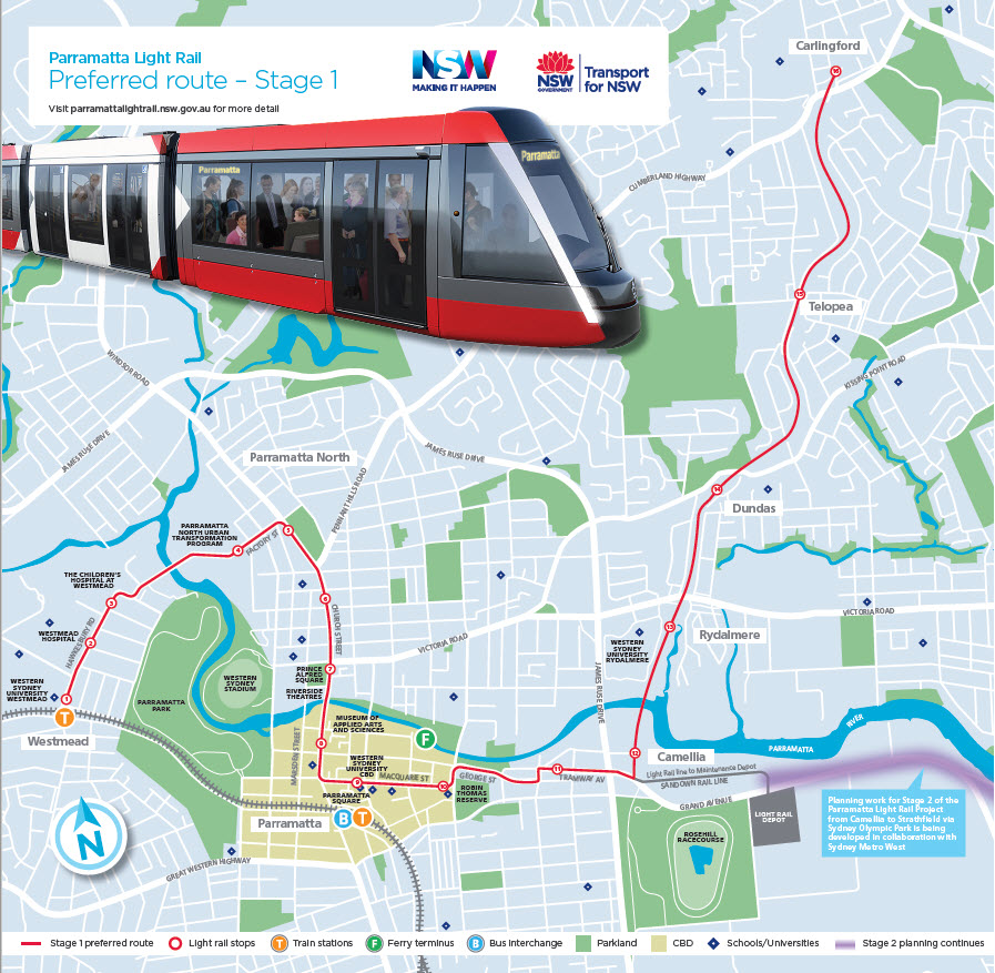
Parramatta Light Rail Stage 1 preferred route (source: NSW Government PRL website)

Parramatta City Council’s 2013 preferred light rail route options (source: Parramatta City Council)
The analysis is made somewhat easier because the line falls into three distinct sections, as outlined below. It’s important to bear in mind however that the route and stop locations are indicative at this stage and could change as a result of further consultation.
Westmead Hospitals and North Parramatta (Stops 1 To 6)
This section is similar to Parramatta Council’s original proposal, though there are some changes. The terminal at Westmead will provide the most direct connection between the rail network and the light rail line. As it runs northeast away from the station, the line will also provide a crucial role in servicing two major hospitals, Westmead and the Children’s Hospital, each of which has a stop. The line will then swing through an arc via the Parramatta North Urban Transformation Program redevelopment area with a stop there before heading back south down Windsor Road where two stops (Factory Street and Fennell Street) will provide potential interchange points with current bus services.
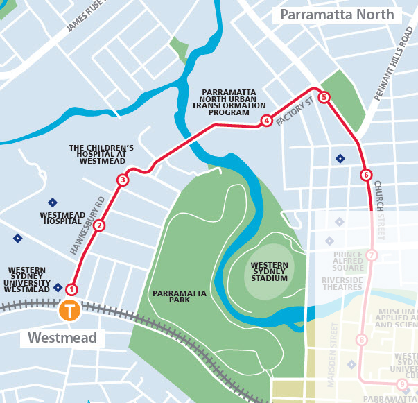
PLR – Westmead Hospitals and North Parramatta (source: NSW Government)
Parramatta Council 2013 preferred route – Westmead to North Parramatta (source Parramatta Council)
Issues:
- While there is a strong case for adopting this corridor, it is obviously not the most direct route between the Parramatta CBD and Westmead. While there are major design and heritage constraints involved, one option worth considering might be to continue the line over the railway on Hawkesbury Road at Westmead and then loop it back to the Parramatta CBD via Alexandra Avenue, Park Parade, Argyle Street and Marsden Street, reconnecting with the planned line at Macquarie Street.
- Close integration with Westmead Station is critical to ensure an easy modal interchange, particularly for patients, people with disabilities and others accessing the hospitals. The indicative map suggests the terminus will be in Hawkesbury Road which is not close enough to the station. A better option would be to terminate the line around the corner in Railway Parade next to the station entrance, or alternatively near the station entrance on the other side of the station in Alexandra Avenue as the start of the loop option described above. Either would also be a better location to handle trams reversing and changing tracks for their return run.
- The specific route the line will take through the controversial Parramatta North Urban Transformation Program precinct is unclear. This section will have to be handled carefully given the heritage and environmental constraints involved.
- This section involves several segments in major road corridors, especially Windsor Road, and it is unclear how this will be handled. There are questions about whether and how there will be track separation for the PRL as well as whether additional road crossing infrastructure, including possibly overbridges, will be provided at light rail stops.
Parramatta CBD (stops 7 to 11)
This section is also very similar to Parramatta Council’s original proposal and forms the heart of the network. The line enters the CBD from the north via Church Street, servicing a range of major current and planned cultural and recreational facilities. There is a stop serving Riverside Theatres and (indirectly) Western Sydney Stadium, and another at the planned site of the Museum of Applied Arts and Sciences. Parramatta’s “Eat Street” runs between these two stops. The line turns at Macquarie Street to run eastwards through the Parramatta CBD, with the stop at Parramatta Square providing the opportunity to access Parramatta station and the neighbouring bus and T-way interchange. As a result this will almost certainly be the busiest section of the system.
The line then heads eastwards with a dogleg via Harris Street to George Street. There is a stop in this section (Harris Street) serving the eastern end of the CBD and providing access to the ferry terminal. There is a further stop at Tramway Avenue before the line heads further east to Camellia.
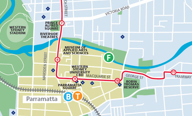
PLR – Parramatta CBD section (source: NSW Government)

Parramatta Council 2013 preferred route – Parramatta CBD section (source Parramatta Council)
Issues:
- While it is probably unavoidable, the interchange between the Parramatta Square stop and Parramatta rail and bus stations involves a walk of over 200 metres. This means that pedestrian access and signage between these two points will be critical in the final design of both the Parramatta Square and PLR projects.
- There is a similar distance between the Harris Street stop and the Parramatta ferry terminal, though this could be reduced by turning the line northwards a block earlier at Charles Street and moving the stop to near the corner of Charles and George Streets.
- In addition Parramatta Stadium, a potential major traffic generator, is over 400 metres from the nearest planned light rail stop at Prince Alfred Square. While the extent to which the PLR will serve as a feeder to the stadium is a little unclear given the line’s relatively small catchment and the interchange issues described above, provision should be made in both the PLR and Parramatta Stadium redevelopment plans for the future construction of a spur line to the stadium.
Camellia and the Carlingford Line (stops 12 to 16)
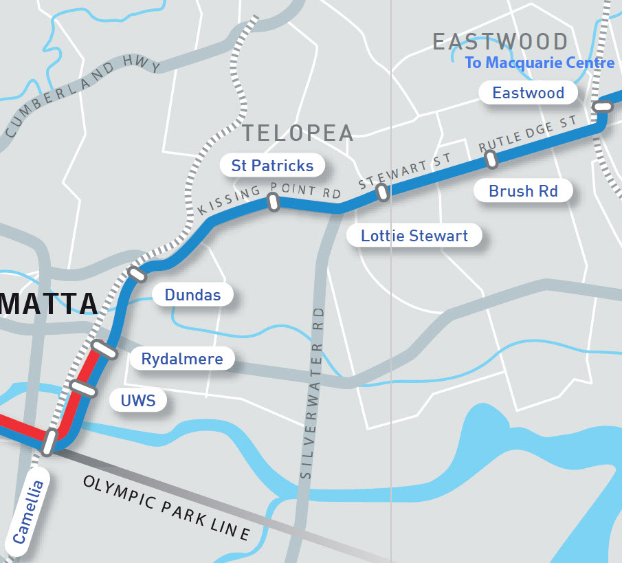
The stop at Camellia marks the end of street running and the start of the Carlingford line conversion. Camellia also services the western end of the Olympic Park redevelopment corridor and will form the likely starting point for the Stage 2 Olympic Park/Strathfield line (the short link leading from the line to a depot to the east of Rosehill Racecourse is the likely start of Stage 2). The line turns north here before veering northeast to follow the alignment of the Carlingford line, running through Rydalmere, Dundas and Telopea stations before terminating at the current Carlingford station. The indicative map suggests these station locations will be maintained as light rail stops.
The duplication of the existing single track rail line and its conversion to become part of Parramatta Light Rail will improve service frequencies in this section. The conversion will also provide direct connectivity from the area currently served by the Carlingford line to Parramatta CBD, Westmead and the Children’s Hospital and eventually the Olympic Park corridor. The light rail line will also greatly improve accessibility for the thousands of students attending the Western Sydney University campus at Rydalmere.
Unlike the other segments of the line, the alignment in this section differs considerably from Parramatta Council’s proposal. This opted for the light rail line to leave the heavy rail corridor at Dundas station and head northeast to connect with the existing Main North heavy rail line at Eastwood and then with the current Parramatta-Epping rail line (and planned metro line) at Macquarie Park. The line now proposed for Stage 1 does however still provide an opportunity for an extension from Carlingford to Epping station and it is understood this option is still under investigation.
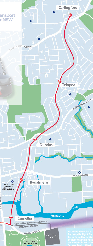
PLR – Carlingford Line section (source: NSW Government)
Parramatta Council 2013 preferred route – Camellia to Macquarie Park (source Parramatta Council)
Issues:
- While it appears logical to place the Camellia stop at the current station site, this is north of the likely location for the start of the Stage 2 line. Moving the stop slightly further south would also better service Rosehill Racecourse (assuming Rosehill station becomes redundant).
- The distances between the existing heavy rail stations on this line north of Dundas are around 1.5 km, somewhat further apart than the optimum 500-metre walk-up catchment for light rail. These locations need to be reviewed and consideration given to adding extra stops if required.
- The position of Rydalmere station is also comparatively distant from the Western Sydney University campus which the line runs past and which it is intended to serve. Consideration should be given to moving the PLR stop about 250-300 metres further south to be closer to the main campus buildings. Given that Rydalmere and Dundas stations are only around 800 metres apart this would still maintain a 500-metre walk-up catchment for both stops.
- When the rail bridge over the Parramatta River is reconstructed for the PLR, a pedestrian walkway and a cycleway should also be included.
- The current plan is silent about what will happen to the remaining section of the existing heavy rail line to the south of Camellia, which connects the Carlingford line via Rosehill Station to Clyde stations on the main west line. The implications are however that this section will be closed. Apart from the impacts on Rosehill Racecourse users and the residents on the western side of James Ruse Drive, this means that rail commuters on the current Carlingford line travelling to the CBD and other centres will be required to travel into Parramatta to access rail services at Parramatta Station via the 200-metre walk described earlier.
- While an extension from Carlingford could provide the basis for an orbital link to the heavy rail and metro interchange at Epping, Parramatta Council’s proposed link from Dundas via Eastwood would have provided similar connectivity and a more direct link to the employment areas around Macquarie Park (the opportunities for potential extensions will be discussed in the next post in this series).
Comments
While it is disappointing that the government announcement has confirmed the retreat from Parramatta Council’s original vision of a connection from the light rail line to Eastwood and Macquarie Park, the line selected still follows much of Parramatta Council’s preferred route. The route, especially the section between Westmead and Camellia is a better option to start with if as the government has indicated the project has to be broken into stages.
The line will greatly improve connectivity between the Parramatta CBD, North Parramatta and the hospital complex at Westmead. It will also provide better links to and from Western Sydney University campus at Rydalmere and from the Carlingford line to downtown Parramatta. The portion of the line between North Parramatta and Camellia in particular is central to the PLR network. As well as providing a circulator within the Parramatta CBD this corridor will act as a central spine with enough capacity to support the planned Stage 2 line and, in the longer term, links to other centres such Castle Hill to the north and Bankstown to the south.
As this analysis has demonstrated however, there are aspects of the preferred route that still need resolution. The location of individual stops relative to transport interchanges and major traffic generators like the hospitals, WSU campuses, redevelopment areas and Parramatta Stadium need to be carefully considered. The options for expanding the network, including the already-foreshadowed Stage 2 link to the Olympic Park corridor will be examined in my next post in this series.

Pingback: Parramatta Light Rail part 3: Stage 1 extension and Stage 2 options | StrategicMatters – the home of The Strategic Week
Pingback: Sydney West Metro and Parramatta Light Rail revisited | StrategicMatters – the home of The Strategic Week