
Recently I had the privilege of spending five weeks in Georgia helping my wife with an art installation. I spent most of my time in Tbilisi on my second visit to this sometimes chaotic but always interesting city which always feels a bit bigger than its population of 1.2 million people. Few people have visited Georgia or its capital, whose transport systems present an interesting contrast to those in Australian cities. It offers some interesting perspectives on transport planning, so in this two-part series I’ll take a look at the city’s urban structure and how people get around it.
The city and its context
It’s hard to understand how Tbilisi works from a transport perspective without knowing something about how the city’s structure evolved. This is closely intertwined with Georgia’s complex history and its current geopolitical status. Both are way too complicated to describe here, but the country along with its neighbours Armenia and Azerbaijan make up the Caucasus and form a major crossroad between Europe and Asia. Not surprisingly Georgia’s location is a key factor in the country’s turbulent and often violent past.

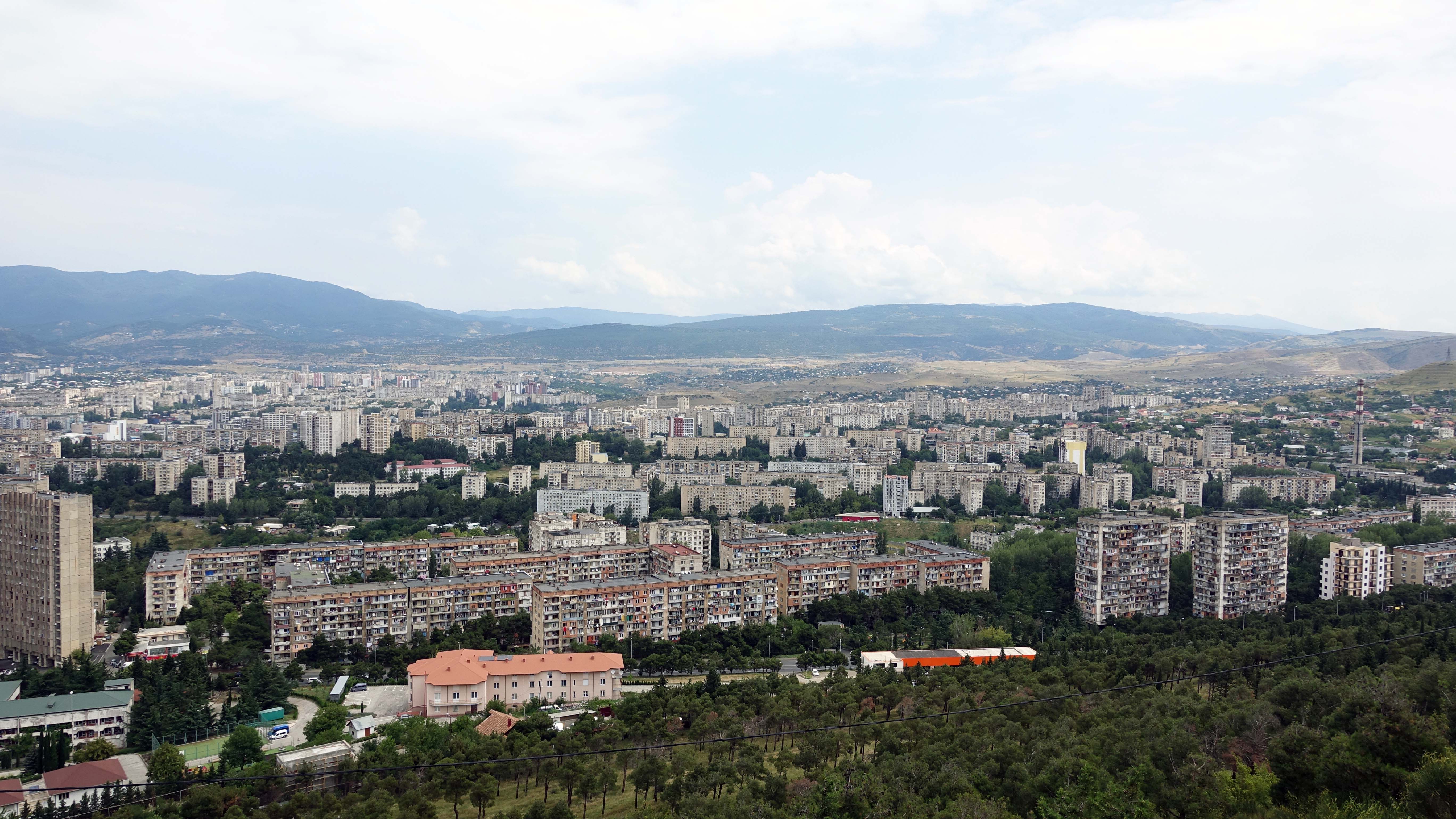
Today, Georgia is just under 70,000 sq km in area, including the occupied provinces of Abkhazia and Ossetia – about the size of Ireland or the Australian state of Tasmania. The population is 3.7 million, roughly one third of whom live in Tbilisi. Tbilisi covers 720 sq km and stretches in a wide 40km long arc from northwest to southeast on either side of the Mtkvari river. The city has expanded particularly to the west but is constrained by the Saguramo and Trialeti Ranges, as well as the Tbilisi Reservoir.
An excellent overview of the city’s history can be found in a paper by Joseph Salukvadze and Oleg Golubchikov which was published in Cities in 2016. The following discussion briefly summarises key aspects of their work.
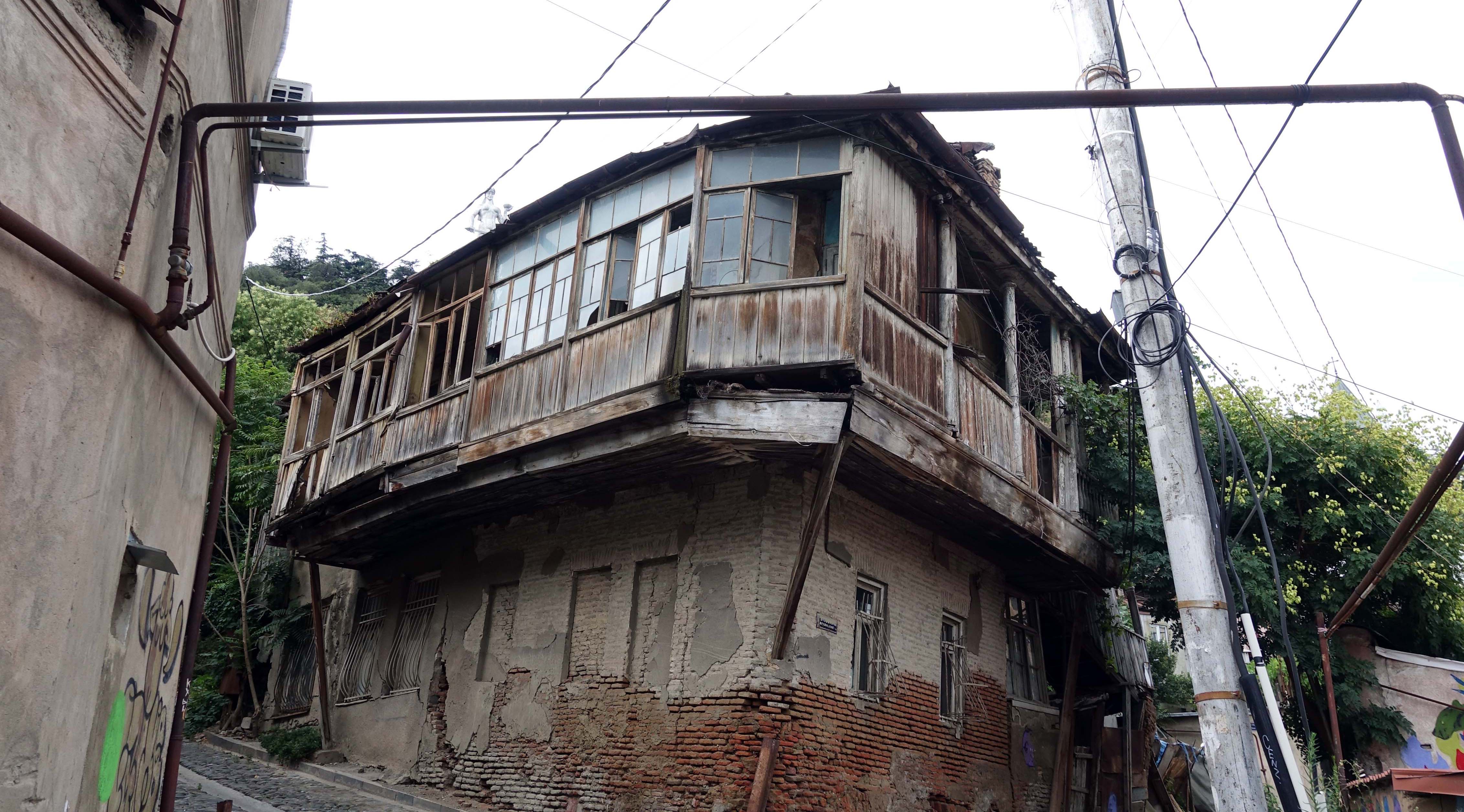
In the 1500 years since Tiblisi was founded the city has been invaded many times, with the Persian invasion of 1795 resulting in its almost complete destruction. Russia then displaced Persian rule and absorbed Georgia into its own empire in 1801. Tbilisi’s strategic location in the Caucasus saw it grow from a town laid out on Medieval lines (traces of which can still be seen in the old city) to a key manufacturing and trade centre. European architectural ideas influenced its street patterns and buildings, as the city housed an increasingly diverse and cosmopolitan population.
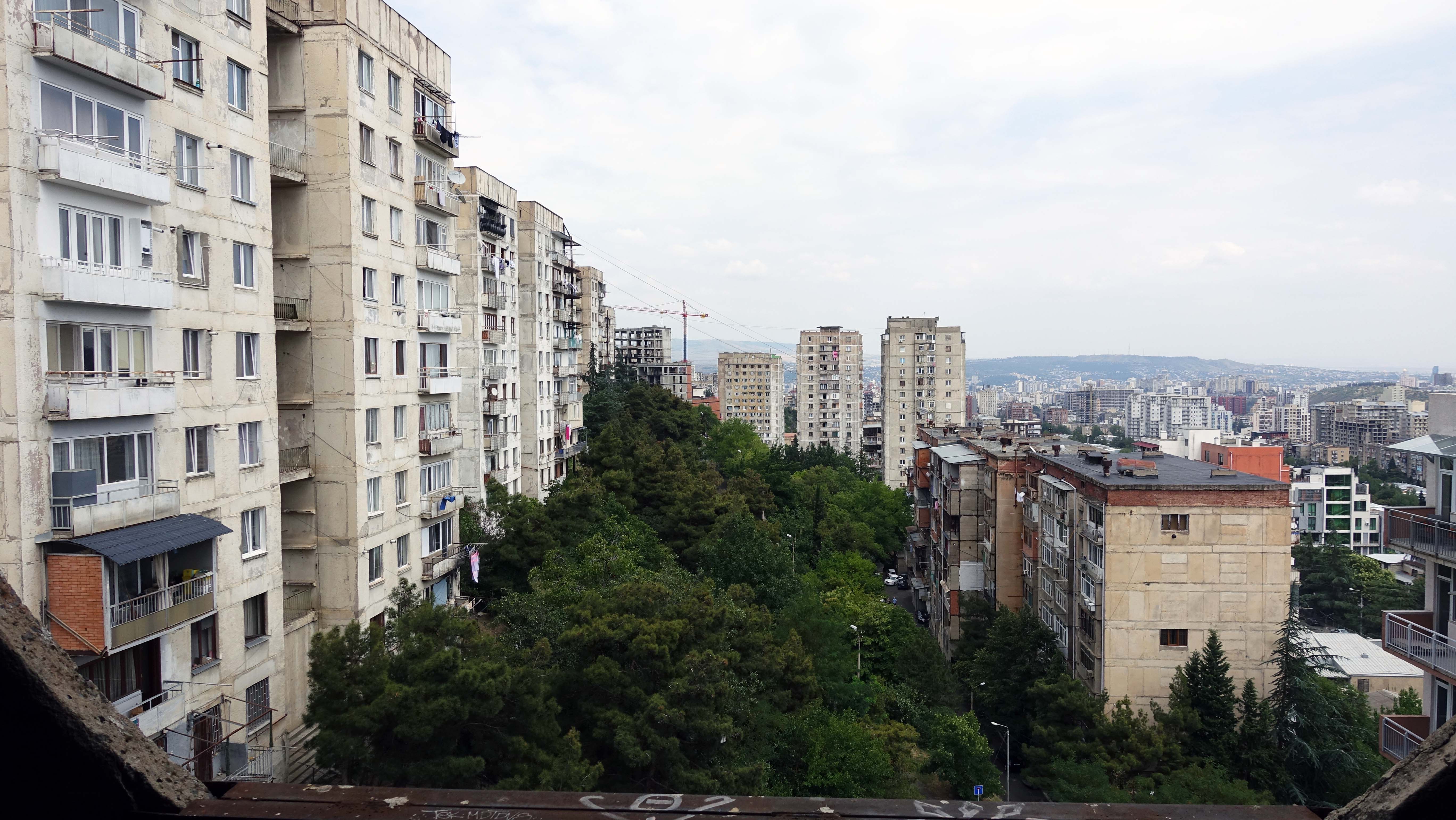
After the Russian revolution of 1917, Georgia briefly proclaimed its independence, but by 1921 it was back under Russian – now Soviet – rule. As Salukvadze and Golubchikov note, the city was further transformed under Soviet rule “from a medium-sized and relatively compact settlement into a large industrial metropolis”, coordinated through a series of masterplans. The city’s boundaries were expanded ten times between 1921 and 1991 and its population grew six-fold, as mass-produced Soviet apartment buildings came to dominate parts of the city, particularly after WW2.
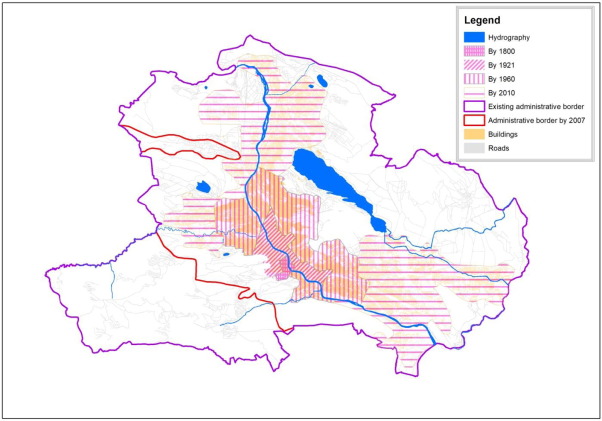
Growth of Tbilisi’s urban area, 1900-2010. Source: Salukvadze and Golubchikov
The years following the demise of the Soviet Union in 1991 were particularly traumatic. As in many other former Soviet countries, coordinated planning was replaced by what Salukvadze and Golubchikov call “laissez faire political ethos… conditioned by the expediencies of capitalism-in-the-making”. In Georgia this was exacerbated by violent internal conflicts and wars with Russia, resulting in economic collapse. In turn, many of Tbilisi’s essential services including public transport ceased to operate for long intervals; some, like trams and trolley buses, never returned.
The resulting tensions led to many Tibilisi residents migrating to Russia and other countries. Many of these were skilled workers who were replaced by less-educated people from rural areas and, in particular, by refugees from the breakaway provinces of Abkhazia and South Ossetia. The problems caused by this migration were compounded by the privatisation of state-owned housing which “…emerged under the conditions of incomplete and weak institutions, poor governance and murky practices” (Salukvadze and Golubchikov). Major residential construction largely ceased, replaced by sub-standard DIY extensions of existing homes and apartments.
In recent years the economic situation has improved, and the development of better property management systems has facilitated housing investment. However, until recently there was little in the way of strategic planning and regulation was still minimal. In 2009 a master plan for the city was adopted, but according to Salukvadze and Golubchikov it “lacks a solid view of what kind of city with what priorities will be developed”. They also claim that “the emerged tradition of ad hoc development has not ceased” with its adoption. A new Land Use Master Plan was released in 2018, but it is too early to judge its impact.
Transport Challenges
Despite ad hoc development and a lack of strategic planning for nearly 30 years, Tbilisi has retained relatively high residential densities which continue to support public transport use. However, the absence of coherent plans has also resulted in a dramatic increase in private car ownership, spurred by the availability of relatively cheap fuel and second-hand vehicles imported from Japan and Europe.
The near-death of the Tbilisi’s public transport also contributed to the increasing use of private cars; these networks are being revived, but still they still suffer from under-investment. This means that the city’s public transport systems, in particular the Metro, have struggled to match Tbilisi’s ever-widening and somewhat-uneven geographic footprint. It’s worth taking a look at how this legacy has shaped the current operations of each of city’s key transport modes.
Tbilisi Metro
Somewhat battered, run on a shoestring and patchily maintained, the Tbilisi Metro continues to be the backbone of the city’s public transport system. Construction began in 1952 before Tbilisi’s population reached one million, which was the usual criteria for a metro in the former Soviet Union. The metro was also only the fourth in the USSR, after Moscow, Saint Petersburg, and Kiev.
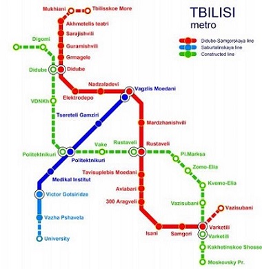
After its opening in 1966 the system was expanded incrementally over the next 25 years into a two-line. However, the economic woes of the post-Soviet era meant it would be nearly three more decades before the final section of the current system opened in 2017, taking the system to 23 stations and 27 km in length (by comparison, the first stage of the Sydney Metro is 36 km and has 13 stations).
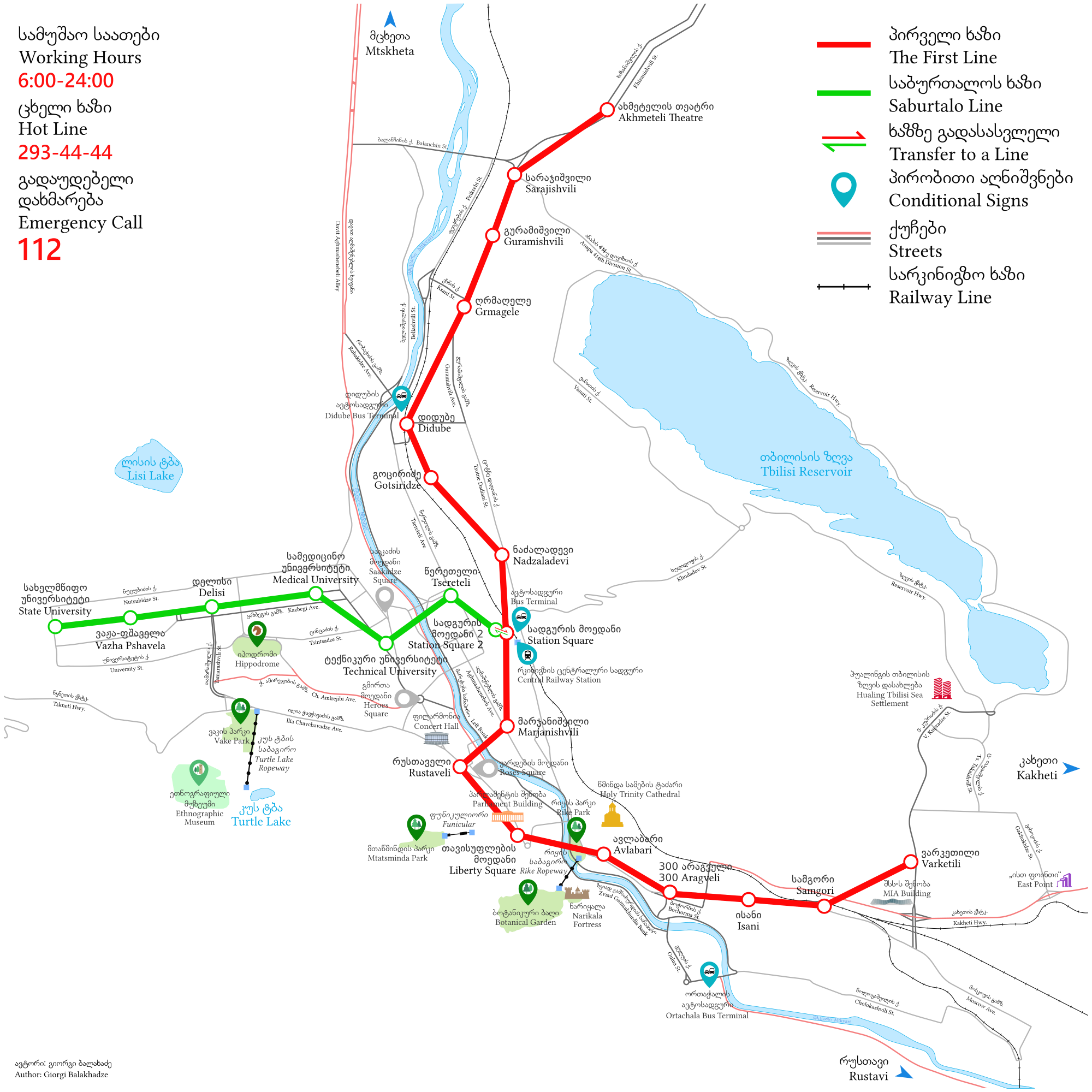
Tbilisi Metro Map. Source: Wikipedia
The metro was particularly hard hit by the political and economic crises of the 1990s. Electricity shortages and blackouts meant that it frequently broke down and at one stage stopped running for several months. It was also subject to petty crime and small-scale terrorist attacks before security was upgraded in 2005. Since then a renovation program has proceeded in fits and starts, but in July 2019 a year-long program began to completely replace the metro’s wiring and ventilation systems.
Due both to Tbilisi’s uneven terrain and the Soviet practice of designing metro stations to double as air raid shelters, much of the system is deep underground. Some stations are over 60 metres deep, accessed by almost 100-metre-long escalators, though two are on the surface. Almost all the underground stations are essentially wide island platforms covered by large vaults. The stations are decorated often quite vividly and in different styles, though not to the ornate levels of the Moscow Metro.
The rolling stock consists of 170 Soviet-built cars made up into four-car (line 1) and three-car (line 2) trains, though the stations can accommodate five-car trains. The trains are typical of the former Soviet era rolling stock found across eastern Europe; solid, durable trains with three doors each carriage side. They are fast, efficient – and incredibly noisy. All the carriages feature longitudinal seating and are in various states of renovation; some are largely original, while others which have been upgraded recently with LED lighting, video information displays and USB charging points.
Operating frequencies range between 2.5 minutes in peak hour and 12 minutes late at night, with large digital displays counting down the arrival of the next train. Services usually run between 6:00am and midnight, but during the current wiring and ventilation replacement program the metro is closing an hour earlier at 11:00pm.
Riding the metro is very cheap with a flat fare of only 0.5 Lari, or 25 cents Australian. The system is accessed with a stored-value smartcard, similar to the Opal card in Sydney or the Oyster card in London. This card can be used on a variety of other transport modes. Not surprisingly given the problems described earlier there was a decline in patronage up until the early 2000s, but in 2017 the metro carried nearly 118 million passengers, a respectable figure for a compact system in a city of 1.2 million.
Riding the Metro
Using any metro for the first time in a foreign country is an exciting experience and this is certainly the case for the Tbilisi Metro, though not in a threatening way. Riding the system was also a marked contrast to my trip on the Sydney Metro a month or two earlier.
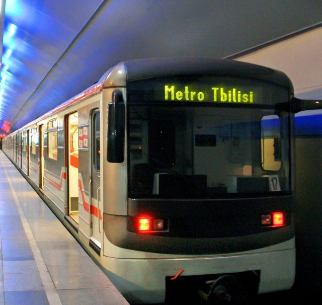
Tbilisi Metro train. Source: Georgia About
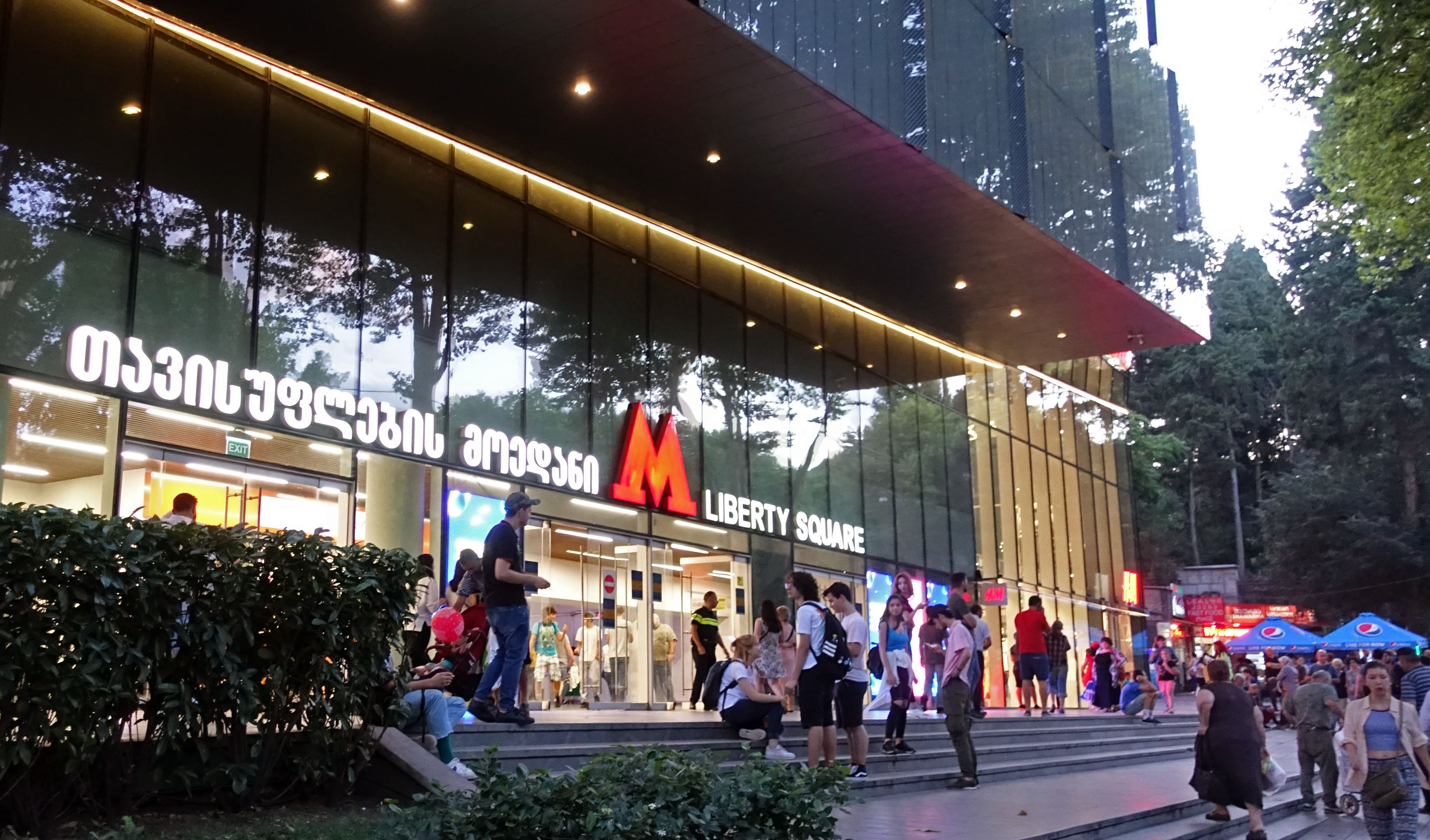
After entering the station and passing at least two or three people trying to sell part-used smartcards, you buy your smartcard at a ticket window. You then use it to pass through a rather antiquated set of turnstiles under the eye of an official, usually a woman, at the top of the escalators.
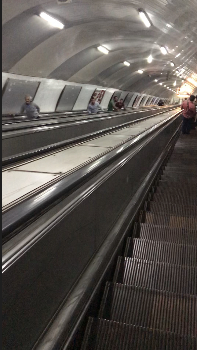 These are the first real surprise. As I said earlier the escalators are exceptionally long which means that the trip down to platform level can take nearly two minutes, almost as long as the trip between adjoining stations. People rarely walk, let alone run; in fact, it’s not unusual for people to sit on the escalator steps.
Arriving at platform level, you pass another woman in a booth. The role of these women seems to be to supervise the escalators – and to stop foreigners taking photographs or videos, which is illegal in the metro. Their presence is also indicative of the high staffing levels of the metro, particularly compared to its highly-automated Sydney counterpart.
As you leave the escalator there is a large sign overhead showing the names of the stations on both lines in Georgian and English. Arrows indicate which platform you need for direction you want to take. The signage is a little rudimentary and confusing the first few times you use the system, but you soon get the hang of it.
On the platform you can watch the countdown clock as you wait for the train, which arrives at speed as zero ticks over on the clock. During most of the day trains are crowded, particularly on line 1, and there is usually a high turnover of passengers at each station. Once you are on the train the next station is announced in both Georgian and English, but it’s useful to work out the count of stations to your destination, as the announcements aren’t always audible. The older carriages have maps of the system but no visual indication of location or the next station. This technology is available on the newer cars but often is not in operation.
Trips are comparatively quick especially given the relatively close (average less than 1 km) distance between stations. You need to hang on as the trains can accelerate and brake quickly and unexpectedly and the ride can also be quite bumpy in places. Ventilation is basic as despite the comparatively hot summers there is no air conditioning, only roof-mounted vents. The trains also appear to be equipped with under-seat heating. Noise levels are very high, to the extent that I began to wonder if this has affected the hearing of regular commuters.
Arriving at your destination is a reverse of boarding. After standing for the long ride up the escalator (and you never see people walking up) you exit the station which is turnstile free (except for some reason at Didube station), an obvious benefit of a flat-fare system. Many of the stations are located next to retail malls, or a linked to nearby streets by pedestrian subways lined with small shops.
Metro limitations and expansion plans
Tbilisi Metro shows clear signs of underinvestment both in terms of systems and infrastructure maintenance, and also the lack of significant expansion.
It’s important to note that there has been some investment in areas such as carriage refurbishment and the systems replacement program I mentioned earlier, but a lot more needs to be done. For example, the Soviet era rolling stock is extremely durable but must be nearing the end of its operating life. Escalators, turnstiles and almost every other aspect of the system need either extensive refurbishment or replacement to bring them up to 21st century standards.
However, there will also be inherent design limitations in attempting to meet these standards. The first is safety, as most stations appear to offer no form of emergency exit from the platform level except via the escalators. Obviously, such exits would be difficult and very expensive to retrofit given the depth of most of the platforms. For similar reasons any form of disabled access, which the system completely lacks, would be difficult to retrofit. Not only are the stations very deep but the length of the escalators means that most station entrances are not directly above the platforms.
The other component of underinvestment, a lack of system expansion, is equally evident. This has exacerbated some of the specific challenges Tbilisi presented for the metro’s original designers. While the core of the city is relatively flat, some sections are very hilly. The flat section is essentially a floodplain bisected by the Mtkvari river, which meant that the designers had not only to deal with river crossings, changes in level and potential flooding, but also with the question of which side of the river the metro should mainly serve.
It seems the metro was originally intended to be a classic Soviet three-line triangle system, albeit with some variations to cope with Tbilisi’s crescent shape. It was decided that the metro’s first line would run mainly on the eastern side of the river servicing key centres like the bus station at Didube and the railway station at Central Square before crossing to the western side to connect to the key central areas around Rustaveli and Freedom Square, close to the old city. It would then cross back over to the eastern side of the river.
Line 2 was designed to service the city’s expansion to the west, starting at an interchange with line 1 near the main railway station then crossing the river to run out to the State university. This like line 1 was eventually built as planned but took decades to complete.
Previous plan for Line 3 (green). Source: Agenda.de
Line 3 was never built. It’s hard to find a definitive map, but the ones I have seen suggest it would have been a very complex project. It’s difficult to describe but it would have filled in some of the missing gaps in the current system, weaving back and forth across the city with three or four interchanges and as many river crossings. Construction of such a line would have involved extensive tunnelling, the cost of which is now likely to be beyond Georgia’s limited resources.
In the past 30 years the system has been extended by only 2.2km, while the city has expanded well beyond its previous limits. The result has left transport planners with a classic dilemma, not dissimilar to that seen in other cities like Sydney – do you try to fill the transport gaps within the established urban area, or attempt to consolidate the growth occurring on the outskirts around new rail stations and lines?
Recently the Georgian government took the latter option. It announced plans for an “above ground” metro to connect from Samgori station on line 1 to the Lilo Market and Tbilisi Airport to the east, with seven stations and the potential to extend to the town of Rustaveli. The line would use part of the existing infrastructure of Tbilisi Bypass Railway, a project which was to build a line around the city, but which was subsequently abandoned. The only map I’ve been able to obtain is a screenshot from a video in Georgian:
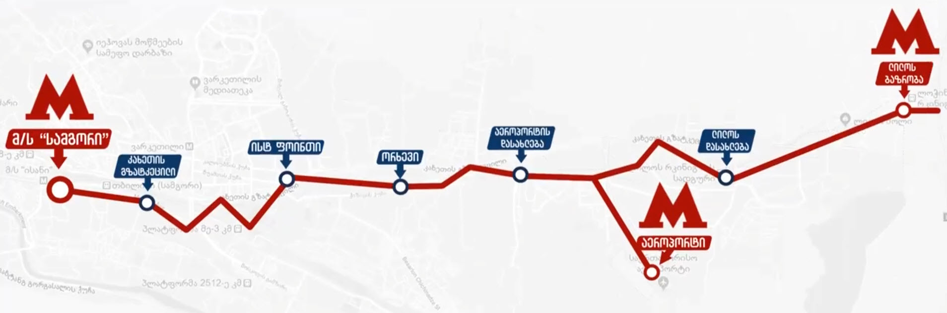
Proposed Tbilisi metro line to the airport and Lilo. Source: Government of Georgia
What this means for the Tbilisi Metro is unclear, but it will help to consolidate the system as the core of the city’s public transport system. Hopefully this system will be further rehabilitated as it is expanded.
In my next post I’ll look at some of the other public transport options in this fascinating city.
* All images apart from those with cited sources are the author’s.

Pingback: Why are motorways good but fast trains bad for regional cities? | StrategicMatters