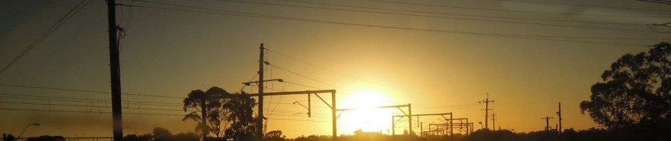
I had intended to write a postscript to my series on the ideas of the engineer John Bradfield and their impact on Sydney in commemoration of the recent 75th anniversary of his death on 23 September 1943, but the NSW Government has, in a sense, beaten me to it.
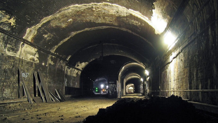
Recently the government announced plans to transform the abandoned tunnels and platforms at St James Station which Bradfield constructed into an entertainment and tourism precinct housing bars, restaurants, shops or galleries, all occupying 6,000 square metres of underground space. This announcement provides a coda to the last article in my series which touched on the abandoned tunnels in discussing Bradfield’s plans for what was effectively a “missing metro” through Sydney’s inner suburbs.
The tunnels formed a key component of Bradfield’s plans. In this light is the announcement by NSW Transport Minister Andrew Constance the wise recycling of redundant assets to encourage tourism, or a short-sighted takeover of valuable public transport infrastructure? It’s worth taking a look at why the tunnels were built, what the government is proposing to do with them and the potential, if any, for their use as transport corridors.
What was Bradfield planning?
Mr Constance states that “the platforms and tunnels were intended to link the Eastern Suburbs with the Northern Beaches but the plans were never completed”. This is incorrect.
Bradfield may have changed his ideas a few times, but it was clearly the lines across the Harbour Bridge that were always intended to prove a northern beaches link – not the tunnels at St James. In fact, while he proposed an interchange, Bradfield never planned a direct connection between his eastern suburbs and northern beaches lines.

Bradfield’s 1925 City Railway plan. Source: R Raxworthy (1989), The Unreasonable Man.
Instead, as I described in more detail in my last article, the St James tunnels were intended to provide an interchange between the City Circle and Bradfield’s planned line which would have run to both the eastern and the western suburbs. Unlike the extra platforms at Town Hall, the additional infrastructure would not only have allowed passengers to interchange, but also would have permitted trains to transfer from the eastern suburbs line to the City Circle, and vice versa.

Bradfield’s 1925 City Railway plan (detail).
The map of Bradfield’s 1925 plans, reproduced in Richard Raxworthy’s biography of John Bradfield, The Unreasonable Man, shows the route (see detail map for a clearer view). Coming from the east, the eastern suburbs line would have run through St James Station from the south (north is to the right of the map) to provide a cross-platform interchange with the City Circle. The line would then have headed north for a short distance but then curved sharply back south almost in a U-turn before running to two stations a short distance apart in the heart of the city.

Diagram of the underground railways proposed in the Sydney CBD by Bradfield. Source: Hornetfig at the English language Wikipedia
The second of these planned stations would have provided an interchange (but not a direct link) with Bradfield’s proposed northern beaches line which would have extended from the Bridge via an interchange with the City Railway at Wynyard and to additional stations just south of Hyde park and east of Central.
Meanwhile, after crossing the northern beaches line, the eastern suburbs line would have proceeded to Town Hall where in effect it would have become the western suburbs line. This would have run south from Town Hall to another station near Railway Square, before turning west to run to the inner western suburbs.
Why were some sections of tunnel built then abandoned?
The Government authorised construction of Bradfield’s plans in two bills; one covering the underground City Railway (what we now call the City Circle) in 1916 and the other the Harbour Bridge, including the rail connection through the city in 1922. Both bills also authorised other connections –the first stages of the eastern and western suburbs lines and the additional tracks across the Harbour Bridge to provide the future northern beaches extension.
The latter section, across the eastern side of the Bridge between North Sydney, Milsons Point and underground platforms at Wynyard, was built but never used by trains. Trams used the corridor until they were scrapped and the line turned into additional traffic lanes across the Bridge.

Sydney’s current CBD Railway lines. Source: Hornetfig at the English language Wikipedia
Bradfield prioritised construction of the City Railway but in doing so he also built two small but critical interchange sections to ensure the eastern and western suburbs lines could be commenced later without too much disturbance to the City Circle. The first was the interchange tunnels and platforms at St James, while the second was extra platforms at Town Hall.
Neither line was completed during Bradfield’s lifetime. This was a consequence of the government’s huge bill for infrastructure projects (including the Bridge), the impact of the Depression and the growth of private vehicle use. Eventually the Eastern Suburbs Railway (ESR) opened in 1979, but only as far as Bondi Junction and on a different alignment to Bradfield’s. The line runs via Martin Place Station instead of the St James interchange, though it does use the spare Town Hall platforms which Bradfield built. The western suburbs line was never constructed.
How much was actually built?
The remaining diagrams show more clearly the relationship between the fragment of Bradfield’s planned eastern suburbs railway that was constructed at St James Station to link to the City Circle. This segment was designed to avoid any at-grade crossings of the tracks for the latter.

Eastern Suburbs Railway interconnection diagram. Source: R Raxworthy (1989), The Unreasonable Man.
From the south the twin tunnels start under Whitlam Square at the intersection of Liverpool and College Streets near the southeast corner of Hyde Park (again, north is to the right of the map). They then cross over the outer City Circle tunnel to run to platforms at St James Station between the existing city Circle ones.

Eastern Suburbs Railway interconnection diagram (detail).
The platforms for the eastern suburbs line were never used and were eventually covered over, which is why there is such a wide gap between the City Circle platforms there. Just north of the station there are also stub tunnels which were once used to reverse trains, as St James was a terminating station before the City Circle was finally completed in 1956.
Heading north from St James, the tunnels cross over the inner City Circle tunnel, veering northwest to start the turn back towards Town Hall Station while the City Circle turns northeast before curving back west to head to Circular Quay Station. This segment of the eastern suburbs tunnels runs under Macquarie Street from the station to a point parallel with the State Library building.
What is the government proposing to do with the tunnels?
The government is seeking expressions of interest (EoIs) “from Australia and around the world to activate the hidden space”. While the Minister states that he wants the “best proposal” it is clear there is also a strong commercial imperative. The EoI process will run for only a little over six weeks and there do not appear to be any plans to run any sort of consultation process to gauge community preferences.
This is far too short a period, and clearly favours those with the resources to put together an adequate response very quickly. This could result in a single private sector bidder being offered effective control of the project and the site, effectively amounting to the wholesale privatisation of a publicly-owned, albeit unused asset. Ideally the redevelopment would provide for widespread community input to the design, ensure public access and incorporate a range of non-profit community and cultural uses as well as commercial ones.
However, there appear to be two positive aspects. One is that only the northern section is being considered, the significance of which I’ll come to in a moment. The second is that the Minister has indicated that the redevelopment of the tunnel could also involve an underground pedestrian connection between St James Station and Martin Place Station, which will also be an interchange station for the Sydney Metro.
If the proposal does go ahead, this would be a sensible idea. The tunnel runs only about 50 metres or so away from Martin Place Station. Adding a connection from there to the station would complement the already-foreshadowed pedestrian link from Martin Place metro station to Wynyard Station, ultimately providing an underground pedestrian corridor across the central CBD from Barangaroo in the west to St James and Hyde Park in the east. A Martin Place entrance is also a simple way of guaranteeing there are multiple exit points in the event of fire or natural disaster from what otherwise could be, literally, a very long dead-end.
Why can’t the tunnels be used as rail corridors?
This is where the Minister has made a rod for his own back. By inferring the purpose of the tunnel was to provide a connection from the eastern suburbs to the northern beaches he inevitably invited the reaction: why doesn’t the government just continue with Bradfield’s plans and build the link?
The fact is the northern section of this tunnel (the portion apparently covered by the EoI) was not designed to go the northern beaches at all and its potential to be extended as a rail corridor is very limited. Its original purpose – to connect the eastern suburbs line back to Town Hall Station via the CBD – has been superseded by the revised route the modern-day Eastern Suburbs Railway takes through Town Hall and Martin Place.
The tunnel is also very shallow as it was constructed by cut-and-cover methods and therefore would be very difficult to extend further in the modern-day CBD, let alone across the harbour. In any case the second cross-harbour rail tunnel is already under construction west of the bridge and any future northern beaches line is likely to be connected to that.
The situation with the southern section is somewhat different and it is interesting that media reports suggest it is not being considered for potential development at this stage. This may be because there are technical issues, or because opening up both sections might put too much pressure on access via St James Station – or possibly because the government wants to stage the project.
There another intriguing possibility; this section is not being redeveloped because unlike the northern section it still has some potential for transport use. I recall (but cannot reference) several proposals in the 1980s or 90s to drive a tunnel connecting the unused platforms at Central Station with those at St James. One suggestion was to use this tunnel to provide additional capacity for suburban services into the CBD; another was to use it to make St James Station the Sydney terminus for a very fast train.
There is a third alternative use. Some time ago I wrote a post on issues relating to the CBD and Southeast Light Rail (CESLR), currently under construction. One of these was capacity, given the CESLR is likely to be full effectively from the first day of operation, and I listed a number of options including a metro line or the extension of the Eastern Suburbs Railway to an interchange with the light rail.
Another option I suggested was to add capacity directly to the CESLR by connecting an additional CBD line from Moore Park to near Oxford Street and then into the spare tunnels and platforms at St James. This would however require the construction of extra tunnels and surface track from Whitlam Square to Moore Park, a route which is complicated by the presence of the Eastern Distributor tunnel.
Ironically, conversion of the southern St James tunnels would echo some of Bradfield’s earlier proposals to put trams underground in the city in a similar manner to Boston’s Green Line. In any event there is a strong argument to retain the southern section and to conduct a comprehensive review of the options for its potential use as transport infrastructure.
Bradfield’s neglected legacy
In his media release the Minister also claimed that, “John Bradfield was a visionary. While his plans to connect Sydney may not have worked in this case, we now have a chance to take what he started and turn it into something that future generations can enjoy.”
This statement is a little disingenuous. The bulk of Bradfield’s “plans to connect Sydney”, as represented by the City Circle, the Harbour Bridge and electrification of the rail network have worked spectacularly well; if his plans “have not worked in this case” that is because his proposed eastern and western suburbs lines were never actually built.
Bradfield’s main shortcoming may have been to plan on too grand a scale, given the limited resources available at the time. It was however the subsequent governments which, blinded by the dramatic post-war rise of car ownership, failed to invest in the rail network for nearly 50 years after the construction of the City Railway and the Harbour Bridge.
By the time later governments belatedly recognised the need for new lines, Sydney was a very different size and shape to the 1920s and it was too late to construct Bradfield’s projects as he planned them. This is a shame, but sensitively adapting the northern tunnels at St James Station for alternative uses incorporating a strong community element while retaining the southern section for potential transport purposes could ensure that his legacy is not entirely wasted.
Updated to add diagram of current CBD rail lines.

I’ve always been a bit confused about where cars enter and exit the tunnels for the disused platforms 1 & 2 of Wynyard station? I have the hardest time visualizing this overlaid over a map.
LikeLike
Hi Greg, this provides a bit more information: https://www.environment.nsw.gov.au/heritageapp/ViewHeritageItemDetails.aspx?ID=4800281
It’s a bit out of date however, and I’m not sure what happened to the car park in the recent major redevelopment of Wynyard station.
LikeLike
So where would one enter the tunnels and where were the exits? The only thing I can find on Google Maps streetview is an exist on Cumberland just south of Essex running along the Western Distrbutor. There was apparently an entrance quite a bit aways from here on Wynward Lane east of the park.
I’m just having a hard time overlaying where the tunnels are in existing to the local streets, and the link quite frankly isn’t much help.
LikeLike
Hi Greg, you’re right about the entrance and exit. The entry was from Wynyard Lane where a short tunnel formed a portal into the side of the old tram tunnels. The exit is as you said in Cumberland Street, roughly opposite 188 Cumberland St.
Originally the tram tracks would have paralleled the rail line on the western side, starting to slope downwards and then (I think) going underground in the vicinity of the Bridge Stairs on Cumberland Street.
I think the tunnels continue underground roughly along the path of the Cahill Expressway until it turns east, then they follow the bus lane to the top of York St. I assume there they start to run parallel to the operational rail lines through Wynyard Station between York and Clarence Streets. I’m not sure how far they run south of the station, if at all.
LikeLike
Okay, I think I got it, now. So the car park was a one-way operations. The (east/track 1) tunnel starts at Wynyard station, where somehow an access tunnel starts at Wynyard Lane and cuts directly west under the park (I wonder if it’s on the same level as the station concourse under the park, or if there is service access from the concourse?) to access the tunnel. The carpark then uses the tunnel (which gradually ascends to the surface along this length) from Wynyard to a bit south of Essex Street, where you are forced out onto Cumberland.
Now, this kind of makes me wonder about the portion of the tunnel between the carpack exit and the portal above Argyle. lol I assume the carpark was walled off at both ends, on the south ends from the former platforms. Kind of also makes me wonder about how the west/track 2 tunnel was accessed for the police shooting range I heard about.
Actually, my description in the first paragraph looks to be incorrect. Here is a diagram I just found of the old carpark:
So, did the carpark use BOTH tunnels, and if so, where does the second tunnel exit onto? I’m not even sure which way this diagram is oriented.
LikeLike
Hi Greg,
The top of the car park diagram you posted is facing roughly west. The diagram is confusing because the carpark used portions of both tunnels and in some sections there was an additional mezzanine level. Edit: both tunnels and the mezzanine joined up before the exit (I recall this because I parked there a couple of times, but unfortunately I don’t remember the layout in detail).
The following diagram provides a bit more context:
https://strategicmatters.files.wordpress.com/2020/05/wynyard-station-cross-section.jpg
Also look for some of the YouTube videos and Vlogs relating to the tunnels, though unfortunately none of them discuss the layout.
LikeLike
I’ve done a bit more digging. The tunnel section you were curious about, between the car park exit and the Bridge Stairs near Argyle Street (which is over 300m of double tunnel), was and possibly still is used by the NSW Railway Institute. There is an entrance under the Bridge Stairs. This Reddit conversation thread has an image of the entrance and discusses its uses, including the firing range. https://www.reddit.com/r/sydney/comments/8ody9u/the_mysterious_nsw_railway_institute/
LikeLike
Here’s another piece of the puzzle – Bradfield’s original layout for the station. This is looking east from York Lane and shows that the tracks sit directly under York Street. The plan shows the upper level of tracks and a portion of the concourse. The existing tracks are the Up and Down Shore Lines (the bottom pair); the remaining Up and Down Shore Local Lines shown were the ones converted for tram operation which then became the car park. https://strategicmatters.files.wordpress.com/2020/05/wynyard-station-original-arrangement.jpg
LikeLike
So, to piece all this together from my various questions…
1. The carpark section of the tunnels must be walled off near the exit unto Cumberland and there was a cut from the west to east tunnel to join them on their northern end. Though, I’m still confused as to why there is an “upper” tunnel (with a mezzanine, apparently. This had to have been built into the tunnel later, and lord only knows how you accessed the the mezzanine.) and “lower” tunnel if they both served a level island platform and concourse back in the day. But I guess that’s a question for another day.
2. The twin tunnels then extend past the walled off carpark section to near Argyle Street. Though, unfortunately, it does not look like the portals are visible in any Google Streetview view, which is just my luck. Argyle is cut too deep to see over the sides, and there appears to be a huge tree blocking the view of the north side of the Bridge Stairs when you try to travel along the Cumberland Street bridge over Argyle Street. Still confused, though, because the portals shown in the reddit thread can’t be at the Bridge Stairs because there is nothing in front of or behind them, nothing for tunnels to go “in” to anywhere. I’m not sure where “under” the Bridge Stairs is except below Argyle Street, and that is a solid rock wall on both sides of the underpass.
LikeLike
I think the only way to get a sense of the geography and topology is to go there in person when that is feasible to do so. The aerial view in Google maps strongly suggests the Bridge Stairs formed the portal for the tramlines, mirroring the current arrangement for the train lines on the western side, with the trams following the Cahill Expressway but descending at this point to the Bridge Stairs, but only halfway to street level. This is also supported by photographs of trams emerging from what looks very much like the Bridge Stairs. I’m not sure of the arrangement of the portals shown in the Reddit thread, but if you look more closely there is some sort of structure above them so they could be at this intermediate level, with the Cahill Expressway overhead. https://www.bing.com/images/search?view=detailV2&ccid=oa5myZzm&id=B214E1F23F15E714C7B2ACB981F10CD56DD9DECD&thid=OIP.oa5myZzm18PCoP9yRB_1CwHaE4&mediaurl=https%3a%2f%2fi.pinimg.com%2foriginals%2fc5%2f67%2f15%2fc567159b88d4b38db9b8ce5bba7a12f1.jpg&exph=481&expw=729&q=trams+on+the+sydney+harbour+bridge&simid=608024397953960106&selectedIndex=22&ajaxhist=0
LikeLike
By coincidence, this image of the tram tracks being removed in this section just popped up in a Facebook group. it shows much more clearly the relationship to the Bridge Stairs. https://tdu.to/i/8338
LikeLike
Okay, this pretty much solves this piece of the puzzle for me. My problem was that I wasn’t visualizing the current auto traffic lanes being built OVER/ON TOP OF the old tram route at this location. This picture shows that very clearly; it’s perfect.
It appears that the level the portals is on is called the Cahill Walk stretching from the walkway along the Habour Bridge steadily descending to the Bridge Stairs. The two eastern-most traffic lanes of the Bradfield Highway bridge approach no longer follow this same level of descent for obvious reasons, but were built over the route of the former trams lines.
I found these pictures. First one is looking north from what I assume is the Bridge Stairs:
Here’s one looking south from the top of the bridge approach; you can faintly make out the Bridge Stairs on the left:
Same view from more recent times, but you can see the trees have overgrown the area obscuring not just the portals but the Bridge Stairs:
If the photos render too large, feel free to remove them or resize them.
LikeLike
I had one additional question. A lot of the descriptions of the Wynyard tram tunnels beyond the car park mention the “Big Fan” they ventilated all six platforms. Do you have any idea where this big fan would be an how it’d be oriented?
LikeLike
The first comment on this History of Sydney blog post refers to the fan and suggests that it was at the Cumberland Street of one of the tunnels. If you recall the image I posted earlier from the Reddit thread of the Railway Institute entrance in the end of one of the tunnels and the barred entrance to the second tunnel, it’s possible that the ventilation fan would be near this entrance. http://www.historyofsydney.com.au/wynyard-station-platforms-1-and-2/
LikeLike
Yeah, that was one of the sites I found the information on. It confuses me, because the way I read it the “big fan” must have always been there; it have been even more imporant during the use of the tunnels by the trams for the fan to have been there. So I wasn’t imaginging this as something having been installed later, and if you’re going to vent a tunnel, you’re doing to do it through the sides or through the top, so it wouldn’t make sense for the fans to be in the tunnel/portals, themselves, unless it was big but not huge and hung/attached from the ceiling. And then what makes it even more confusing is that they say it was used to ventilate ALL six platforms.
So, really, I have no idea. lol Anyway, thanks for all of the information and your patience.
LikeLike
Thanks Greg. I’m guessing but I think the fan was installed after the conversion of the tunnels, mainly to vent the exhaust fumes from the car park but with enough capacity to provide some ventilation to the station as well.
If the fan is at the end of the tunnel then obviously it was installed after the conversion. In any case I don’t think any other Sydney station was designed by Bradfield with this level of ventilation.
LikeLike
Finally read the whole post. But I caught something:
“Heading north from St James, the tunnels cross over the inner City Circle tunnel…”
It looks like the old, disused Eastern Suburbs tunnels north of the station actually go UNDER the inner City Circle tunnel.
BTW, how was it possible to use the stub-end tunnels north of the station to reverse trains if they were physically seperated by platforms and such? Where the existing City Circle inner and outer tunnels somehow connected to this stub-end before they where extended to Circle Quay?
LikeLike
On that last point, I found these pictures.
http://cdn.newsapi.com.au/image/v1/567b40a61f2938870cce5ab96a891289?width=650
https://cdn.newsapi.com.au/image/v1/6e3f4113f8fc4a70c254e44eeb3d7832?width=1024
So I guess all of these tunnels were connected with access/side tunnels before they their grade seperates, at least the northern tunnels. So had this line been built out, I guess it would have been possible to for trains to physically interchange between lines.
Still curious about any diagram/drawings showing the setup of all these side tunnels begin and end and how far after the platforms in all four tunnels. And the disused south tunnels look to be setup significantly differently to these. I’m not even sure if I’ve seen pictures of platforms in these tunnels.
LikeLike
Trains I reckon. You could connect the Metro West to Martin Place and then run them onto Bondi Junction. Then you would do something similar to this plan with the old Eastern Suburbs line platforms running the line to Northern Beaches. There’d be moving walkways connecting Martin Place to the double decker stations.
LikeLike
Interesting idea, assuming you could get the grades right between where Sydney Metro West is planned to enter the CBD and Martin Place station.
However, contracts have already been let for at least some of the project so its never going to happen. Also the platforms at St James would probably require a very steep grade down to a tunnel under the harbour to the northern beaches.
The current ESR tunnels at Town Hall could be a more feasible starting point, but either way no government’s going to pay for a third harbour rail crossing. In addition this idea would put all the Illawarra line trains back on the City Circle when one of the reasons the government gives for building the CBD and SW metro is to reduce the number of trains on the CC.
If there is ever to be a line to the northern beaches (which I don’t think will happen in my lifetime) it’s much more likely to run from an interchange with the NW metro at Victoria Cross station in North Sydney.
LikeLike
Very interesting analysis and many lost opportunities. The Bradfield plan was a true master plan.
Do you know if the final Bradfield plan (I think 1926) for the Eastern Suburbs was still to have flyover junction connection just south of Erskineville like some many of the drawings illustrate.
Also the 1926 plan connects the Eastern and Western loops together with a station at railway square. Then continuing west down Parramatta road with a station at the University gate. Do you know where it went beyond here? Do it head north at Annandale and up through Balmain or did it continue west to Strathfield?
Also, I read somewhere that tunneling for the Eastern Suburbs line had started in the Taylor Square area but was stopped before it made it to St James. Do you know if that actually happened?
Also I think with the disbanded tunnels north of St James could be connected to the ESR at Martin Place with out too much trouble and used as an underground pedestrian link. Then once Hunter Street station is opened in the 2030s you could walk underground all the way from Barangaroo to Hyde Park.
LikeLike